IMAGES TAKEN NEAR TO
Maes Yr Haul, MOLD, CH7 1NS
Introduction
This page details the photographs taken nearby to Maes Yr Haul, CH7 1NS by members of the Geograph project.
The Geograph project started in 2005 with the aim of publishing, organising and preserving representative images for every square kilometre of Great Britain, Ireland and the Isle of Man.

There are currently over 7.5m images from over14,400 individuals and you can help contribute to the project by visiting https://www.geograph.org.uk
Image Map
Images are licensed for reuse under creativecommons.org/licenses/by-sa/2.0
Notes
- Clicking on the map will re-center to the selected point.
- The higher the marker number, the further away the image location is from the centre of the postcode.
Image Listing (7 Images Found)
Images are licensed for reuse under creativecommons.org/licenses/by-sa/2.0
Image
Details
Distance
1
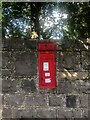
Victorian postbox on Ruthin Road
Cast iron wall box
Image: © Eirian Evans
Taken: 5 Oct 2021
0.11 miles
3
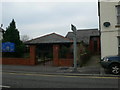
Capel Bethel, Yr Wyddgrug
Bethel, a joint Independent Chapel and Methodist Church on New Street, Mold
Image: © Eirian Evans
Taken: 15 Feb 2008
0.21 miles
4
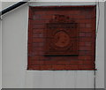
Jubilee Plaque
Dated 1897, this tiled plaque is on a house front on New Street, Mold. It lists all the countries over which Victoria was queen.
Image: © Eirian Evans
Taken: 15 Feb 2008
0.21 miles
5
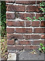
Bench mark in Brook Street, Mold
This bench mark is at the end of an alley just off Brook Street, Mold. See also: Image
Image: © John S Turner
Taken: 8 Jul 2014
0.23 miles
6
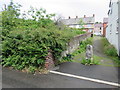
Alley off Brook Street, Mold
This alley links Brook Street, and Gladstone Street in Mold. There is a bench mark cut into the brickwork nearest the camera, facing across the alley. See: Image
Image: © John S Turner
Taken: 8 Jul 2014
0.23 miles
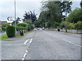
7
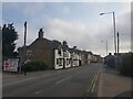
Ruthin Castle
Looking along New Street in Mold.
Image: © DS Pugh
Taken: 9 Aug 2020
0.24 miles