IMAGES TAKEN NEAR TO
Milford Street, MOLD, CH7 1GP
Introduction
This page details the photographs taken nearby to Milford Street, CH7 1GP by members of the Geograph project.
The Geograph project started in 2005 with the aim of publishing, organising and preserving representative images for every square kilometre of Great Britain, Ireland and the Isle of Man.

There are currently over 7.5m images from over14,400 individuals and you can help contribute to the project by visiting https://www.geograph.org.uk
Image Map
Images are licensed for reuse under creativecommons.org/licenses/by-sa/2.0
Notes
- Clicking on the map will re-center to the selected point.
- The higher the marker number, the further away the image location is from the centre of the postcode.
Image Listing (145 Images Found)
Images are licensed for reuse under creativecommons.org/licenses/by-sa/2.0
Image
Details
Distance
1
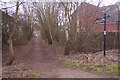
The Mold Railway Path
Part of the old railway route through Mold has been dedicated as a public footpath by Flintshire County Council. Access is available here from Milford Street. Although passenger services to Mold ended in 1962 the stretch here continued to be used by freight trains until 1983 and the track was not lifted until 1985.
Image: © Stephen McKay
Taken: 12 Feb 2019
0.01 miles
2
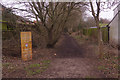
The Mold Railway Path
Part of the old railway route through Mold has been dedicated as a public footpath by Flintshire County Council. Access is available here from Milford Street. Although passenger services to Mold ended in 1962 the stretch here continued to be used by freight trains until 1983 and the track was not lifted until 1985. The footpath was formally opened in 2010 and, as the wooden board explains, was winner of the Bovril Great Outdoors Revival rambling category.
Image: © Stephen McKay
Taken: 12 Feb 2019
0.04 miles
3

Love Lane, Mold
Seen here from King Street, Love Lane gives access to a car park but this was once the route of the railway through Mold. Passenger services ceased in 1962 but this stretch continued to be used by freight trains until 1983.
Image: © Stephen McKay
Taken: 12 Feb 2019
0.11 miles
4
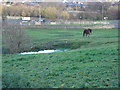
Horse field north of St Mary's church in Mold
Image: © Aaron Thomas
Taken: 2 Dec 2006
0.14 miles
5
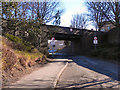
Love Lane, Mold
The bridge carrying King Street over Love Lane.
Image: © David Dixon
Taken: 22 Mar 2011
0.15 miles
6
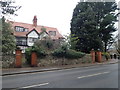
Semi-detached villas on King Street
Built in 1910.
Image: © Eirian Evans
Taken: 10 Jan 2019
0.15 miles
7
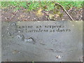
Inscription, St Mary's Churchyard
Some of the gravestones at St Mary's Church have been taken down, some line the churchyard, others form the pavements. This is an inscription which has lost its "owner".
Image: © Eirian Evans
Taken: 1 Apr 2011
0.15 miles
8
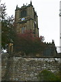
St Mary's Church, Mold
The church tower, seen from the High Street. The church was built about 1490 to commemorate Henry Tudor's victory at the Battle of Bosworth in 1485.
Image: © Eirian Evans
Taken: 29 Sep 2007
0.15 miles
9
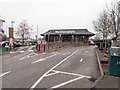
Mold's McDonald's
Drive-through cafe near Aldi in Mold
Image: © Eirian Evans
Taken: 10 Jan 2019
0.15 miles
10
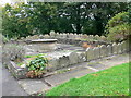
Gravestones, St Mary's Church, Mold
Large areas of the churchyard have been made into a car park and the gravestones have been moved and reset. The large graveyard is no longer open for burials.
Image: © Eirian Evans
Taken: 29 Sep 2007
0.15 miles