IMAGES TAKEN NEAR TO
King Street, MOLD, CH7 1EF
Introduction
This page details the photographs taken nearby to King Street, CH7 1EF by members of the Geograph project.
The Geograph project started in 2005 with the aim of publishing, organising and preserving representative images for every square kilometre of Great Britain, Ireland and the Isle of Man.

There are currently over 7.5m images from over14,400 individuals and you can help contribute to the project by visiting https://www.geograph.org.uk
Image Map
Images are licensed for reuse under creativecommons.org/licenses/by-sa/2.0
Notes
- Clicking on the map will re-center to the selected point.
- The higher the marker number, the further away the image location is from the centre of the postcode.
Image Listing (166 Images Found)
Images are licensed for reuse under creativecommons.org/licenses/by-sa/2.0
Image
Details
Distance
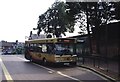
1
Mold Police Station
As seen from the Bus Station.
Image: © Eirian Evans
Taken: 13 Feb 2012
0.01 miles
2
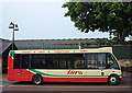
Mold Bus Station
Route number 2, Chester to Ruthin, waiting at Mold
Image: © michael ely
Taken: 10 May 2008
0.03 miles
3

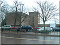
Old railway route through Mold
Looking down from the King Street bridge, Mold's railway ran along this alignment and the station was the other side of the Chester Street bridge ahead. Passenger services were withdrawn in 1962 although freight trains continued to run here until 1983. The building on the left is an Aldi store and to the right the town's police station.
Image: © Stephen McKay
Taken: 12 Feb 2019
0.03 miles

6
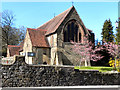
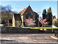
St Mary's Church Hall, Mold
St Mary's Church Hall on King Street, Mold, was formerly St John the Evangelist Church, built in 1878-9 by John Douglas.
Image: © David Dixon
Taken: 22 Mar 2011
0.04 miles
7
St Mary's Church Hall, Mold
St Mary's Church Hall on King Street, Mold, was formerly St John the Evangelist Church, built in 1878-9 by John Douglas.
Image: © David Dixon
Taken: 22 Mar 2011
0.04 miles
8
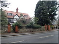
Semi-detached villas on King Street
Built in 1910.
Image: © Eirian Evans
Taken: 10 Jan 2019
0.04 miles
9
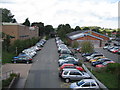
Track of old railway
A view looking north along the track of the dismantled railway line, now used for car parking. I can recall steam engines in use on this line before its closure to passenger services on 30 April 1962. Freight services continued on the line until it finally closed in March 1983.
Image: © Phil Williams
Taken: 26 Sep 2006
0.05 miles
10

Steam Wheel
A view looking north from Chester Street towards a sculpture near the bridge over the old railway line. The design is titled "Steam Wheel" and is by Martin Williams. It does seem to reflect a wheel and motion from a steam locomotive, and it is positioned near the site of the old station. See http://www.cywaithcymru.org/eng/archive_detail.php?projectsID=69 for more information.
The tower of Mold Fire Station can be seen in the background, with Theatr Clwyd and County Hall visible on the skyline in the far distance.
Image: © Phil Williams
Taken: 26 Sep 2006
0.05 miles