IMAGES TAKEN NEAR TO
Bryn Dyrys, BAGILLT, CH6 6BX
Introduction
This page details the photographs taken nearby to Bryn Dyrys, CH6 6BX by members of the Geograph project.
The Geograph project started in 2005 with the aim of publishing, organising and preserving representative images for every square kilometre of Great Britain, Ireland and the Isle of Man.

There are currently over 7.5m images from over14,400 individuals and you can help contribute to the project by visiting https://www.geograph.org.uk
Image Map (Loading...)


Getting Data...Please wait
Leaflet Map data © OpenStreetMap
Images are licensed for reuse under creativecommons.org/licenses/by-sa/2.0
Notes
- Clicking on the map will re-center to the selected point.
- The higher the marker number, the further away the image location is from the centre of the postcode.
Image Listing (3 Images Found)
Images are licensed for reuse under creativecommons.org/licenses/by-sa/2.0
Image
Details
Distance
1
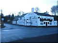
The Blossoms, Bagillt
A view looking southwest across what used to be the main A548 before the Bagillt bypass was built, to the junction of Bryn Tirion Road, with the Blossoms public house on the corner.
Image: © Phil Williams
Taken: 1 Jan 2006
0.22 miles
2
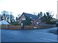
Ffordd Bryn Tirion, Bagillt
This building at the corner of Ffordd Bryn Tirion was formerly a church and is now a private residence.
Image: © Phil Williams
Taken: 1 Jan 2006
0.22 miles
3
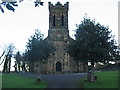
Bagillt church
A view looking southeast to the church at Bagillt.
Image: © Phil Williams
Taken: 1 Jan 2006
0.24 miles