IMAGES TAKEN NEAR TO
Merllyn Lane, BAGILLT, CH6 6BG
Introduction
This page details the photographs taken nearby to Merllyn Lane, CH6 6BG by members of the Geograph project.
The Geograph project started in 2005 with the aim of publishing, organising and preserving representative images for every square kilometre of Great Britain, Ireland and the Isle of Man.

There are currently over 7.5m images from over14,400 individuals and you can help contribute to the project by visiting https://www.geograph.org.uk
Image Map (Loading...)


Getting Data...Please wait
Leaflet Map data © OpenStreetMap
Images are licensed for reuse under creativecommons.org/licenses/by-sa/2.0
Notes
- Clicking on the map will re-center to the selected point.
- The higher the marker number, the further away the image location is from the centre of the postcode.
Image Listing (55 Images Found)
Images are licensed for reuse under creativecommons.org/licenses/by-sa/2.0
Image
Details
Distance
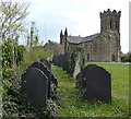
1
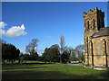
The graveyard and tower of St Mary's, Bagillt
Looking north-west across the graveyard of St Mary's on a bright February day.
Image: © John S Turner
Taken: 12 Feb 2011
0.10 miles
2
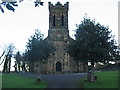
Bagillt church
A view looking southeast to the church at Bagillt.
Image: © Phil Williams
Taken: 1 Jan 2006
0.11 miles
3
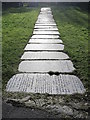
Gravestone pathway in St Mary and St Peter's, Bagillt
The churchyard of St Mary and St Peter has been cleared and some of the gravestones have been made into a pathway.
Image: © John S Turner
Taken: 12 Feb 2011
0.11 miles
4
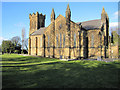
The south side of St Mary's, Bagillt
A view of the south side of St Mary's, Bagillt. The church was begun in 1837 and was completed in 1839.
Image: © John S Turner
Taken: 12 Feb 2011
0.13 miles
5
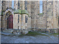
The base of St Mary's church tower, Bagillt
A view of the north side of the church tower with the north door. There is a very weathered 1GL bench mark and bolt on the buttress in the corner, facing north-west. See Image
Image: © John S Turner
Taken: 12 Feb 2011
0.13 miles
6
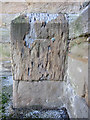
Damaged 1 GL bench mark and bolt on St Mary's tower
This early bench mark and bolt is looking very weathered on the soft stone of the church tower. It is on the north side of the tower facing north-west. See also Image
Image: © John S Turner
Taken: 12 Feb 2011
0.13 miles
7
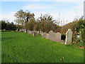
Gravestones in St Mary and St Peter's churchyard, Bagillt
A serried row of gravestones, some of which have been moved to the side of the churchyard.
Image: © John S Turner
Taken: 1 Nov 2017
0.13 miles
8
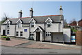
The Upper Shippe inn, Bagillt
A plaque commemorating Dafydd ap Llywelyn is on the wall of the inn and remembers prince Dafydd ap Llywelyn's birth place at Castell Hen Blas. The unveiling ceremony was performed by former Plaid Cymru leader Dafydd Wigley and took place on July 26th 2010, 770 years to the day since Dafydd ap Llywelyn visited Castell Hen Blas.
Image: © clive dyke
Taken: 28 Mar 2011
0.14 miles
10
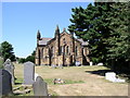
St Mary's Church, Bagillt
The church of St. Mary, Bagillt was built between 1837 and 1839, and was consecrated on 18 July 1839 as a "chapel of ease" within the parish of Holywell. It became the parish church of the new parish of Bagillt in 1844.
Image: © Eirian Evans
Taken: 17 Jul 2006
0.14 miles