IMAGES TAKEN NEAR TO
Brightsmith Road, CH66 4BT
Introduction
This page details the photographs taken nearby to Brightsmith Road, CH66 4BT by members of the Geograph project.
The Geograph project started in 2005 with the aim of publishing, organising and preserving representative images for every square kilometre of Great Britain, Ireland and the Isle of Man.

There are currently over 7.5m images from over14,400 individuals and you can help contribute to the project by visiting https://www.geograph.org.uk
Image Map
Images are licensed for reuse under creativecommons.org/licenses/by-sa/2.0
Notes
- Clicking on the map will re-center to the selected point.
- The higher the marker number, the further away the image location is from the centre of the postcode.
Image Listing (6 Images Found)
Images are licensed for reuse under creativecommons.org/licenses/by-sa/2.0
Image
Details
Distance
1

Capenhurst 400 / 275kV Substation
This is the large National Grid Substation that supplies a considerable area around the Ellesmere Port industrial area. It is that big that it has sections within three different Grid Squares. This is the North West side of the Substation in the given Grid Square and the other sections are also in squares SJ3674 and SJ3774.
Image: © David Neale
Taken: 7 Jul 2006
0.11 miles
2
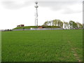
Reservoir and communications mast
At the water treatment works near Sutton Green
Image: © Maggie Cox
Taken: 3 May 2013
0.19 miles
6
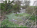
Pond beside footpath junction
Footpaths between Ledsham, Little Sutton, Great Sutton and Sutton Green
Image: © Maggie Cox
Taken: 3 May 2013
0.25 miles