IMAGES TAKEN NEAR TO
Fern Close, FLINT, CH6 5TR
Introduction
This page details the photographs taken nearby to Fern Close, CH6 5TR by members of the Geograph project.
The Geograph project started in 2005 with the aim of publishing, organising and preserving representative images for every square kilometre of Great Britain, Ireland and the Isle of Man.

There are currently over 7.5m images from over14,400 individuals and you can help contribute to the project by visiting https://www.geograph.org.uk
Image Map
Images are licensed for reuse under creativecommons.org/licenses/by-sa/2.0
Notes
- Clicking on the map will re-center to the selected point.
- The higher the marker number, the further away the image location is from the centre of the postcode.
Image Listing (7 Images Found)
Images are licensed for reuse under creativecommons.org/licenses/by-sa/2.0
Image
Details
Distance
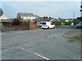
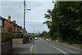
3
Halkyn Road in Flint
Looking along Halkyn Road on the outskirts of Flint.
Image: © DS Pugh
Taken: 7 Aug 2020
0.19 miles
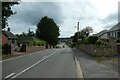
4
Halkyn Road heading towards Flint town centre
Image: © Maggie Cox
Taken: 26 Oct 2013
0.19 miles
5
Halkyn Road in Flint
Looking down Halkyn Road in the outskirts of Flint.
Image: © DS Pugh
Taken: 7 Aug 2020
0.20 miles
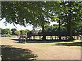
6
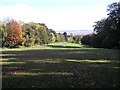
Cornist Park, Flint
Cornist Park with Castle Heights in the background and The Dee Estuary and Wirral in the distance.
Image: © George Lloyd
Taken: 21 Oct 2008
0.23 miles
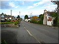
7
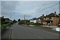
Approaching Hillside Way
Looking along Halkyn Road on the outskirts of Flint.
Image: © DS Pugh
Taken: 7 Aug 2020
0.23 miles