IMAGES TAKEN NEAR TO
Paper Mill Lane, FLINT, CH6 5SX
Introduction
This page details the photographs taken nearby to Paper Mill Lane, CH6 5SX by members of the Geograph project.
The Geograph project started in 2005 with the aim of publishing, organising and preserving representative images for every square kilometre of Great Britain, Ireland and the Isle of Man.

There are currently over 7.5m images from over14,400 individuals and you can help contribute to the project by visiting https://www.geograph.org.uk
Image Map (Loading...)


Getting Data...Please wait
Leaflet Map data © OpenStreetMap
Images are licensed for reuse under creativecommons.org/licenses/by-sa/2.0
Notes
- Clicking on the map will re-center to the selected point.
- The higher the marker number, the further away the image location is from the centre of the postcode.
Image Listing (1 Images Found)
Images are licensed for reuse under creativecommons.org/licenses/by-sa/2.0
Image
Details
Distance
1
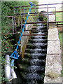
Sluice
This is the run-off from the reservoir. Further down the hill, you can see water pipes leading to the paper mill. Presumably, this device controls the supply.
Image: © Peter Craine
Taken: 20 Aug 2006
0.24 miles