IMAGES TAKEN NEAR TO
Ash Grove, FLINT, CH6 5RX
Introduction
This page details the photographs taken nearby to Ash Grove, CH6 5RX by members of the Geograph project.
The Geograph project started in 2005 with the aim of publishing, organising and preserving representative images for every square kilometre of Great Britain, Ireland and the Isle of Man.

There are currently over 7.5m images from over14,400 individuals and you can help contribute to the project by visiting https://www.geograph.org.uk
Image Map (Loading...)


Getting Data...Please wait
Leaflet Map data © OpenStreetMap
Images are licensed for reuse under creativecommons.org/licenses/by-sa/2.0
Notes
- Clicking on the map will re-center to the selected point.
- The higher the marker number, the further away the image location is from the centre of the postcode.
Image Listing (14 Images Found)
Images are licensed for reuse under creativecommons.org/licenses/by-sa/2.0
Image
Details
Distance
1
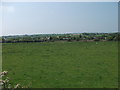
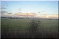
View across Panton Cop
Beyond the low lying ground behind the sea wall is the eastern end of Bagillt.
Image: © John Haynes
Taken: 24 May 2012
0.07 miles
2
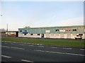
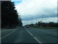
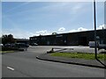
Industrial units adjacent to the A548
A view looking north across the A548 to the industrial units which have replaced the Crosville 'bus depot which used to occupy this site.
Image: © Phil Williams
Taken: 2 Jan 2006
0.09 miles
3
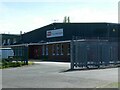
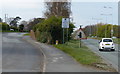
Industrial and office building, Bagillt
Image: © David Smith
Taken: 23 Apr 2024
0.10 miles
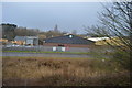
6
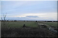
Car park outside industrial building, Bagillt
Image: © David Smith
Taken: 23 Apr 2024
0.15 miles