IMAGES TAKEN NEAR TO
Cornist Lane, FLINT, CH6 5RH
Introduction
This page details the photographs taken nearby to Cornist Lane, CH6 5RH by members of the Geograph project.
The Geograph project started in 2005 with the aim of publishing, organising and preserving representative images for every square kilometre of Great Britain, Ireland and the Isle of Man.

There are currently over 7.5m images from over14,400 individuals and you can help contribute to the project by visiting https://www.geograph.org.uk
Image Map
Images are licensed for reuse under creativecommons.org/licenses/by-sa/2.0
Notes
- Clicking on the map will re-center to the selected point.
- The higher the marker number, the further away the image location is from the centre of the postcode.
Image Listing (3 Images Found)
Images are licensed for reuse under creativecommons.org/licenses/by-sa/2.0
Image
Details
Distance
1
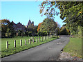
Cornist Hall, Flint
Cornist Drive leading to Cornist Hall, former home of Thomas Totty, an admiral who served with Lord Nelson. In 1889 it became the residence of the Summers steel family.
Image: © George Lloyd
Taken: 21 Oct 2008
0.05 miles
3
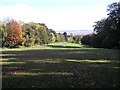
Cornist Park, Flint
Cornist Park with Castle Heights in the background and The Dee Estuary and Wirral in the distance.
Image: © George Lloyd
Taken: 21 Oct 2008
0.25 miles