IMAGES TAKEN NEAR TO
Coed Y Bryn, FLINT, CH6 5QP
Introduction
This page details the photographs taken nearby to Coed Y Bryn, CH6 5QP by members of the Geograph project.
The Geograph project started in 2005 with the aim of publishing, organising and preserving representative images for every square kilometre of Great Britain, Ireland and the Isle of Man.

There are currently over 7.5m images from over14,400 individuals and you can help contribute to the project by visiting https://www.geograph.org.uk
Image Map (Loading...)


Getting Data...Please wait
Leaflet Map data © OpenStreetMap
Images are licensed for reuse under creativecommons.org/licenses/by-sa/2.0
Notes
- Clicking on the map will re-center to the selected point.
- The higher the marker number, the further away the image location is from the centre of the postcode.
Image Listing (7 Images Found)
Images are licensed for reuse under creativecommons.org/licenses/by-sa/2.0
Image
Details
Distance
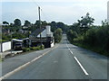
1
Pentre Hill from Llys Pen-Y-Glyn junction
Image: © Colin Pyle
Taken: 9 Aug 2020
0.06 miles
2
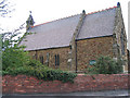
St Thomas Church, Flint Mountain
Flint Mountain is the name of the village, it's actually on a small hill.
Image: © Peter Craine
Taken: 20 Aug 2006
0.12 miles
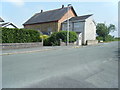
4
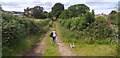
Footpath at Flint Mountain/Mynydd Fflint
A good track which leads away from Flint Mountain/Mynydd Fflint.
Image: © Colin Kinnear
Taken: 31 Jul 2020
0.15 miles
5
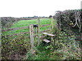
Stile for footpath heading towards Starkey Lane
From Flint Mountain
Image: © Maggie Cox
Taken: 26 Oct 2013
0.19 miles
6

The Coach
The Coach and Horses on the A5119 at Flint Mountain.
Image: © George Lloyd
Taken: 20 Mar 2006
0.24 miles