IMAGES TAKEN NEAR TO
Marsh Lane, FLINT, CH6 5PJ
Introduction
This page details the photographs taken nearby to Marsh Lane, CH6 5PJ by members of the Geograph project.
The Geograph project started in 2005 with the aim of publishing, organising and preserving representative images for every square kilometre of Great Britain, Ireland and the Isle of Man.

There are currently over 7.5m images from over14,400 individuals and you can help contribute to the project by visiting https://www.geograph.org.uk
Image Map (Loading...)


Getting Data...Please wait
Leaflet Map data © OpenStreetMap
Images are licensed for reuse under creativecommons.org/licenses/by-sa/2.0
Notes
- Clicking on the map will re-center to the selected point.
- The higher the marker number, the further away the image location is from the centre of the postcode.
Image Listing (307 Images Found)
Images are licensed for reuse under creativecommons.org/licenses/by-sa/2.0
Image
Details
Distance
1
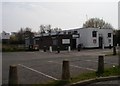
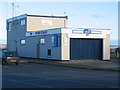
Flint Town United Social Club
Viewed from close to the Lifeboat Station
Image: © Christopher Hall
Taken: 8 Apr 2015
0.04 miles
3
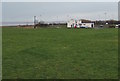
Flint Town United Social Club
Flint Town United's ground is in a spectacular location on the bank of the River Dee estuary, close to the historic castle. The club was formed in 1886 as Flint FC and like many such clubs has had a chequered history, however, in the 2006-2007 season they won the North Wales Challenge Cup.
http://en.wikipedia.org/wiki/Flint_Town_United_F.C.
Image: © John S Turner
Taken: 4 Mar 2010
0.05 miles
4
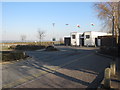
Towards Flint Lifeboat Station
At the edge of the Dee Estuary, viewed from the grounds of Flint Castle. http://www.geograph.org.uk/photo/5466913
Image: © Jaggery
Taken: 16 Jan 2017
0.05 miles
5
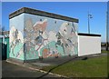
Mural at Bardyn Waste Water pumping station
The pumping station has been given a make-over with a mural depicting a 13th Century battle which took place in Flint.
Image: © Eirian Evans
Taken: 3 Feb 2012
0.06 miles
6
Fflint Inshore Lifeboat station
The inshore lifeboat station at Fflint, home to a D-Class lifeboat if I recall correctly.
Image: © Phil Williams
Taken: 1 Jan 2006
0.06 miles
7
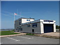
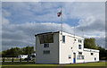
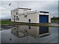
Flint Royal National Lifeboat Institution station
Flint RNLI station is unique in that it faces inshore as many of the rescues with its trailer mounted D Class inshore Lifeboat are reached by road along the A548. It has a slipway but it is dry at low tide.
http://www.rnli.org.uk/rnli_near_you/west/stations/FlintFlintshire
Image: © John Haynes
Taken: 22 May 2012
0.06 miles
8
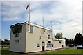
RNLI IRB Station, Flint
The inflatable rescue boat (IRB) station on the Dee Estuary at Flint.
Image: © Jeff Buck
Taken: 31 May 2013
0.06 miles
10
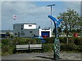
Sustrans mile marker, Castle Dyke Street, Flint
The IRB building is in the background
Image: © David Smith
Taken: 23 Apr 2024
0.07 miles