IMAGES TAKEN NEAR TO
Waen Isa, FLINT, CH6 5NZ
Introduction
This page details the photographs taken nearby to Waen Isa, CH6 5NZ by members of the Geograph project.
The Geograph project started in 2005 with the aim of publishing, organising and preserving representative images for every square kilometre of Great Britain, Ireland and the Isle of Man.

There are currently over 7.5m images from over14,400 individuals and you can help contribute to the project by visiting https://www.geograph.org.uk
Image Map
Images are licensed for reuse under creativecommons.org/licenses/by-sa/2.0
Notes
- Clicking on the map will re-center to the selected point.
- The higher the marker number, the further away the image location is from the centre of the postcode.
Image Listing (4 Images Found)
Images are licensed for reuse under creativecommons.org/licenses/by-sa/2.0
Image
Details
Distance
1
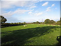
Sheep grazing in a field
With the Dee Estuary and The Wirral in the far distance
Image: © Maggie Cox
Taken: 26 Oct 2013
0.20 miles
2
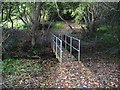
Footbridge over stream in woodland
Neither the stream or the woodland are named on my OS map
Image: © Maggie Cox
Taken: 26 Oct 2013
0.20 miles
3
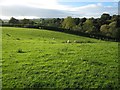
Sheep grazing in a field
In the far distance is Halkyn Mountain
Image: © Maggie Cox
Taken: 26 Oct 2013
0.22 miles
4
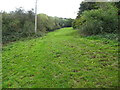
Narrow sloping grazing field
Beside unnamed woodland
Image: © Maggie Cox
Taken: 26 Oct 2013
0.24 miles