IMAGES TAKEN NEAR TO
Tudor Avenue, FLINT, CH6 5LZ
Introduction
This page details the photographs taken nearby to Tudor Avenue, CH6 5LZ by members of the Geograph project.
The Geograph project started in 2005 with the aim of publishing, organising and preserving representative images for every square kilometre of Great Britain, Ireland and the Isle of Man.

There are currently over 7.5m images from over14,400 individuals and you can help contribute to the project by visiting https://www.geograph.org.uk
Image Map (Loading...)


Getting Data...Please wait
Leaflet Map data © OpenStreetMap
Images are licensed for reuse under creativecommons.org/licenses/by-sa/2.0
Notes
- Clicking on the map will re-center to the selected point.
- The higher the marker number, the further away the image location is from the centre of the postcode.
Image Listing (5 Images Found)
Images are licensed for reuse under creativecommons.org/licenses/by-sa/2.0
Image
Details
Distance
3
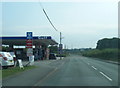
A5119 Northop Road at Gulf filling station
Image: © Colin Pyle
Taken: 9 Aug 2020
0.19 miles
4
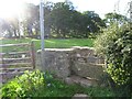
Stone Stile on Northop Road south of Flint
For footpath leading to Halkyn Road
Image: © Maggie Cox
Taken: 26 Oct 2013
0.21 miles
5
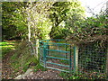
Metal kissing gate
On a footpath heading south east from Northop Road
Image: © Maggie Cox
Taken: 26 Oct 2013
0.21 miles