IMAGES TAKEN NEAR TO
Woodfield Avenue, FLINT, CH6 5JG
Introduction
This page details the photographs taken nearby to Woodfield Avenue, CH6 5JG by members of the Geograph project.
The Geograph project started in 2005 with the aim of publishing, organising and preserving representative images for every square kilometre of Great Britain, Ireland and the Isle of Man.

There are currently over 7.5m images from over14,400 individuals and you can help contribute to the project by visiting https://www.geograph.org.uk
Image Map (Loading...)


Getting Data...Please wait
Leaflet Map data © OpenStreetMap
Images are licensed for reuse under creativecommons.org/licenses/by-sa/2.0
Notes
- Clicking on the map will re-center to the selected point.
- The higher the marker number, the further away the image location is from the centre of the postcode.
Image Listing (77 Images Found)
Images are licensed for reuse under creativecommons.org/licenses/by-sa/2.0
Image
Details
Distance
1
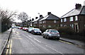
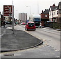
Woodfield Avenue, Flint
From Chester Road along Woodfield Avenue towards Prince of Wales Avenue.
Image: © Jaggery
Taken: 16 Jan 2017
0.02 miles
2
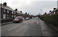
Trelawny Avenue, Flint
From Chester Road along Trelawny Avenue towards Prince of Wales Avenue.
Image: © Jaggery
Taken: 16 Jan 2017
0.06 miles
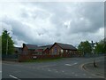
3
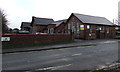
Woodfield Avenue side of Ysgol Croes Atti, Flint
The west side of the primary school. http://www.geograph.org.uk/photo/5256901 to a view of the school across Chester Road.
Image: © Jaggery
Taken: 16 Jan 2017
0.07 miles
4
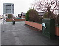
Chester Road telecoms cabinet near Woodfield Avenue, Flint
A notice on the cabinet states Fibre Broadband Is Here. Woodfield Avenue is ahead on the right.
Image: © Jaggery
Taken: 16 Jan 2017
0.08 miles
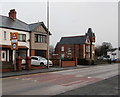
5
Flint Castle direction sign
Facing Chester Road near the corner of Woodfield Avenue in the southeast outskirts of Flint.
Image: © Jaggery
Taken: 16 Jan 2017
0.08 miles
7
Warning sign - Patrol/Hebryngwr, Chester Road, Flint
The bilingual (English/Welsh) sign and a 20mph maximum speed sign face
the A548 Chester Road on the approach to a primary school, Ysgol Croes Atti http://www.geograph.org.uk/photo/5256901
Image: © Jaggery
Taken: 16 Jan 2017
0.09 miles
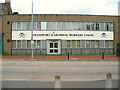
10
Teddy Bear Towers Day Nursery and Vogue Hair Fashions name signs, Flint
Located here http://www.geograph.org.uk/photo/5266452 outside Trelawney Towers.
Image: © Jaggery
Taken: 16 Jan 2017
0.09 miles