IMAGES TAKEN NEAR TO
Ffordd Madog, FLINT, CH6 5GF
Introduction
This page details the photographs taken nearby to Ffordd Madog, CH6 5GF by members of the Geograph project.
The Geograph project started in 2005 with the aim of publishing, organising and preserving representative images for every square kilometre of Great Britain, Ireland and the Isle of Man.

There are currently over 7.5m images from over14,400 individuals and you can help contribute to the project by visiting https://www.geograph.org.uk
Image Map (Loading...)


Getting Data...Please wait
Leaflet Map data © OpenStreetMap
Images are licensed for reuse under creativecommons.org/licenses/by-sa/2.0
Notes
- Clicking on the map will re-center to the selected point.
- The higher the marker number, the further away the image location is from the centre of the postcode.
Image Listing (20 Images Found)
Images are licensed for reuse under creativecommons.org/licenses/by-sa/2.0
Image
Details
Distance
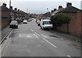
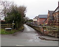
1
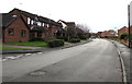
Caesar Avenue, Flint
Looking to the SSW along Caesar Avenue past the corner of Mill Croft.
Image: © Jaggery
Taken: 16 Jan 2017
0.11 miles
2
Julius Close, Flint
Cul-de-sac on the northwest side of Caesar Avenue.
Image: © Jaggery
Taken: 16 Jan 2017
0.16 miles
3
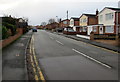
Caesar Avenue, Flint
From the corner of Chester Road.
Image: © Jaggery
Taken: 16 Jan 2017
0.16 miles
4
Mill Croft, Flint
Cul-de-sac on the southeast side of Caesar Avenue.
Image: © Jaggery
Taken: 16 Jan 2017
0.17 miles
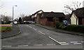
5
Albert Avenue, Flint
From the corner of Chester Road along Albert Avenue towards Prince of Wales Avenue.
Image: © Jaggery
Taken: 16 Jan 2017
0.21 miles
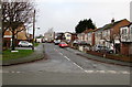
6
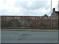
Old stone and brick wall, Chester Road, Flint
Image: © David Smith
Taken: 6 May 2023
0.21 miles
7

Deeside Shuttle bus in the outskirts of Flint
Heading towards the town centre on the A548 Chester Road.
Image: © Jaggery
Taken: 16 Jan 2017
0.22 miles
8
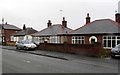
Three bungalows in the outskirts of Flint
Viewed across the A548 Chester Road in the southeast of Flint.
Originally, bungalow was used in English for a lightly-built house, with a veranda and one storey.
In current UK usage it is a convenient word for any one-storey dwelling.
Image: © Jaggery
Taken: 16 Jan 2017
0.23 miles
9
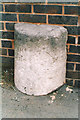
Old Milestone by the A548, Chester Road, Pentre, Flint
Milestone by the A548, in parish of Flint (Flintshire District), by No. 253, Chester Road, against wall, Northeast side of road.
Inscription once read:-
: (Queensferry / 5 Miles) : : (Flint / 1 Mile) :
Surveyed
Milestone Society National ID: FLT_FLQF01
Image: © Milestone Society
Taken: Unknown
0.23 miles
10
Croes Atti Lane, Oakenholt
Dead-end lane viewed across the A458 Chester Road.
Image: © Jaggery
Taken: 16 Jan 2017
0.23 miles