IMAGES TAKEN NEAR TO
Chwylfa Lane, FLINT, CH6 5FZ
Introduction
This page details the photographs taken nearby to Chwylfa Lane, CH6 5FZ by members of the Geograph project.
The Geograph project started in 2005 with the aim of publishing, organising and preserving representative images for every square kilometre of Great Britain, Ireland and the Isle of Man.

There are currently over 7.5m images from over14,400 individuals and you can help contribute to the project by visiting https://www.geograph.org.uk
Image Map (Loading...)


Getting Data...Please wait
Leaflet Map data © OpenStreetMap
Images are licensed for reuse under creativecommons.org/licenses/by-sa/2.0
Notes
- Clicking on the map will re-center to the selected point.
- The higher the marker number, the further away the image location is from the centre of the postcode.
Image Listing (6 Images Found)
Images are licensed for reuse under creativecommons.org/licenses/by-sa/2.0
Image
Details
Distance
1
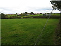
Grazing fields west of Chwylfa Farm
With distant views of The Dee Estuary and The Wirral
Image: © Maggie Cox
Taken: 26 Oct 2013
0.07 miles
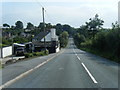
3

The Coach
The Coach and Horses on the A5119 at Flint Mountain.
Image: © George Lloyd
Taken: 20 Mar 2006
0.11 miles
4
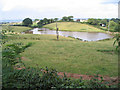
Lake, Bryn-y-garreg
I suspect this is an artificial lake, as it's not shown on my map...
Image: © Peter Craine
Taken: 20 Aug 2006
0.14 miles
5
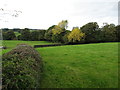
Grazing fields and woodland
The Afon Conwy runs through the woodland and the delightfully named Snowdrop Hill is behind
Image: © Maggie Cox
Taken: 26 Oct 2013
0.21 miles
6
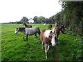
Ponies on a footpath through a grazing field
Near Bryn y garreg
Image: © Maggie Cox
Taken: 26 Oct 2013
0.21 miles