IMAGES TAKEN NEAR TO
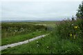
Chester Road, FLINT, CH6 5EH
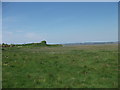
Introduction
This page details the photographs taken nearby to Chester Road, CH6 5EH by members of the Geograph project.
The Geograph project started in 2005 with the aim of publishing, organising and preserving representative images for every square kilometre of Great Britain, Ireland and the Isle of Man.

There are currently over 7.5m images from over14,400 individuals and you can help contribute to the project by visiting https://www.geograph.org.uk
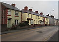
Image Map (Loading...)


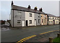
Getting Data...Please wait
Leaflet Map data © OpenStreetMap
Images are licensed for reuse under creativecommons.org/licenses/by-sa/2.0
Notes
- Clicking on the map will re-center to the selected point.
- The higher the marker number, the further away the image location is from the centre of the postcode.
Image Listing (69 Images Found)
Images are licensed for reuse under creativecommons.org/licenses/by-sa/2.0
Image
Details
Distance
1

Paths near the Dee estuary
Looking at a junction of several paths in Flint.
Image: © DS Pugh
Taken: 8 Aug 2020
0.07 miles
2
Gate beside the Dee estuary
Looking along a footpath on the banks of the Dee estuary.
Image: © DS Pugh
Taken: 8 Aug 2020
0.08 miles
3
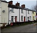
Short row of houses set back from the north side of Chester Road, Flint
The houses are aligned at right angles to the course of Chester Road behind the camera.
Image: © Jaggery
Taken: 16 Jan 2017
0.08 miles
4
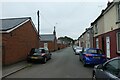
Street of houses in Flint
Looking along Dee Cottages.
Image: © DS Pugh
Taken: 8 Aug 2020
0.09 miles
5
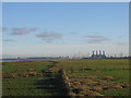
Saltmarshes on the Dee Estuary
A view looking southeast over the saltmarshes of the Dee estuary, an important habitat for wild birds. The four stacks of the gas-fired power station at Connahs Quay can be seen at right, with the tower of the cable-stayed Flintshire Bridge to its left. The twin stacks of the Shotton power station are at the left of the picture.
Image: © Phil Williams
Taken: 1 Jan 2006
0.09 miles
6
Chester Road houses, Flint
Viewed across the A548 Chester Road. The houses on the far right face the Queens Road junction.
Image: © Jaggery
Taken: 16 Jan 2017
0.10 miles
7
Chester Road houses, Flint
Viewed from the corner of Queens Avenue. The side road on the
left leads to a bridge over the North Wales Coast Line railway.
Image: © Jaggery
Taken: 16 Jan 2017
0.10 miles
8
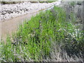
Marsh samphire
Salicornia europaea It emerges from the mud of the salt marsh in summer. Bright green shoots, which can be collected when still very young and tender, just a few inches high. Boil them but not for long, they're best eaten almost raw.
Image: © Eirian Evans
Taken: 17 Jul 2006
0.10 miles
9
Llwybr Arfordir Cymru
A new path for the Wales Coast Path towards Flint promenade.
Image: © John Haynes
Taken: 22 May 2012
0.10 miles
10
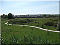
New look out point
The highest spot on this part of the salting is the ideal place.
Image: © John Haynes
Taken: 22 May 2012
0.11 miles