IMAGES TAKEN NEAR TO
Duke Street, FLINT, CH6 5DJ
Introduction
This page details the photographs taken nearby to Duke Street, CH6 5DJ by members of the Geograph project.
The Geograph project started in 2005 with the aim of publishing, organising and preserving representative images for every square kilometre of Great Britain, Ireland and the Isle of Man.

There are currently over 7.5m images from over14,400 individuals and you can help contribute to the project by visiting https://www.geograph.org.uk
Image Map (Loading...)


Getting Data...Please wait
Leaflet Map data © OpenStreetMap
Images are licensed for reuse under creativecommons.org/licenses/by-sa/2.0
Notes
- Clicking on the map will re-center to the selected point.
- The higher the marker number, the further away the image location is from the centre of the postcode.
Image Listing (277 Images Found)
Images are licensed for reuse under creativecommons.org/licenses/by-sa/2.0
Image
Details
Distance
1
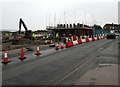
Chapel Street building site, Flint
Work in progress in mid January 2017.
Image: © Jaggery
Taken: 16 Jan 2017
0.04 miles
2
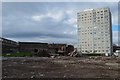
Maisonette demolition, Flint
Muspratt Walk is the third of nine blocks of maisonettes to be demolished as part of the regeneration of Flint town centre.
Image: © Matt Harrop
Taken: 18 Feb 2015
0.05 miles
3
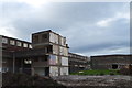
Maisonette demolition, Flint 3
Muspratt Walk is the third of nine blocks of maisonettes to be demolished as part of the regeneration of Flint town centre.
Image: © Matt Harrop
Taken: 18 Feb 2015
0.05 miles
4
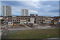
Maisonette demolition, Flint 2
Muspratt Walk is the third of nine blocks of maisonettes to be demolished as part of the regeneration of Flint town centre.
Image: © Matt Harrop
Taken: 18 Feb 2015
0.05 miles
5
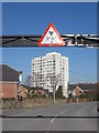
Lon y Becws and Castle Heights
Looking under the height barrier of the car park in Lon y Becws towards the hi-rise block called Castle Heights.
Image: © John S Turner
Taken: 4 Mar 2010
0.07 miles
6
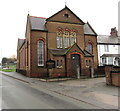
Caersalem, Eglwys Bresbyteraidd Cymru, Y Fflint
Viewed across Chapel Street. The Welsh title means Caersalem (Jerusalem) Welsh Presbyterian Church, Flint. This is the 1877 rebuild of Caersalem Methodist Chapel which was built in 1836.
The information board http://www.geograph.org.uk/photo/5371976 is in Welsh only.
Image: © Jaggery
Taken: 16 Jan 2017
0.07 miles
8

Information board outside Caersalem, Flint
Text on the board located here http://www.geograph.org.uk/photo/5371971 is in Welsh.
Image: © Jaggery
Taken: 16 Jan 2017
0.07 miles
9

Park Avenue, Flint
From Chester Street along Park Avenue towards Prince of Wales Avenue.
Image: © Jaggery
Taken: 16 Jan 2017
0.08 miles
10
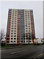
Castle Heights, Flint
Castle Heights on the corner of Chapel Street and Sydney Street
is one of three multistorey blocks of flats in Flint town centre.
Image: © Jaggery
Taken: 16 Jan 2017
0.08 miles