IMAGES TAKEN NEAR TO
Puffin Close, ELLESMERE PORT, CH65 9JP
Introduction
This page details the photographs taken nearby to Puffin Close, CH65 9JP by members of the Geograph project.
The Geograph project started in 2005 with the aim of publishing, organising and preserving representative images for every square kilometre of Great Britain, Ireland and the Isle of Man.

There are currently over 7.5m images from over14,400 individuals and you can help contribute to the project by visiting https://www.geograph.org.uk
Image Map (Loading...)


Getting Data...Please wait
Leaflet Map data © OpenStreetMap
Images are licensed for reuse under creativecommons.org/licenses/by-sa/2.0
Notes
- Clicking on the map will re-center to the selected point.
- The higher the marker number, the further away the image location is from the centre of the postcode.
Image Listing (4 Images Found)
Images are licensed for reuse under creativecommons.org/licenses/by-sa/2.0
Image
Details
Distance
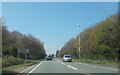
1
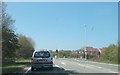
Stanney Woods Avenue junction with A5117
Image: © John Firth
Taken: 21 Apr 2015
0.09 miles
2
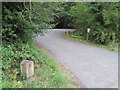
Stanney Woods car park and a boundary stone
The car park for Stanney Woods is accessed from the A5117 Strawberry Way East. The 'CHESTER 2002' boundary stone indicates that the Chester boundary now follows the line of the road, whereas the older boundary used to zig-zag through the woods behind. For a close up of the stone see Image
Image: © John S Turner
Taken: 14 Aug 2018
0.15 miles
4
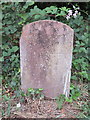
'CHESTER 2002' boundary stone by Stanney Woods
This standard design sandstone Chester boundary stone stands at the entrance to the car park for Stanney Woods alongside the A5117 Strawberry Way East. The inscription simply reads 'CHESTER 2002' For a wider view see Image
Image: © John S Turner
Taken: 14 Aug 2018
0.16 miles