IMAGES TAKEN NEAR TO
Princes Road, ELLESMERE PORT, CH65 8EZ
Introduction
This page details the photographs taken nearby to Princes Road, CH65 8EZ by members of the Geograph project.
The Geograph project started in 2005 with the aim of publishing, organising and preserving representative images for every square kilometre of Great Britain, Ireland and the Isle of Man.

There are currently over 7.5m images from over14,400 individuals and you can help contribute to the project by visiting https://www.geograph.org.uk
Image Map
Images are licensed for reuse under creativecommons.org/licenses/by-sa/2.0
Notes
- Clicking on the map will re-center to the selected point.
- The higher the marker number, the further away the image location is from the centre of the postcode.
Image Listing (4 Images Found)
Images are licensed for reuse under creativecommons.org/licenses/by-sa/2.0
Image
Details
Distance
1
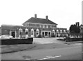
The Wheatsheaf
A Wetherspoon's pub near Overpool station.
Image: © Des Blenkinsopp
Taken: 27 Apr 2012
0.19 miles
2
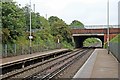
Bridge, Overpool Railway Station
Overpool Road bridge is at the end of the platforms, looking towards Ellesmere Port.
Image: © El Pollock
Taken: 8 Jun 2012
0.23 miles
4
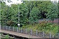
Entrance ramp and flora, Overpool Railway Station
There are similar walkways, leading down to the station, on both sides of the tracks. Viewed from the Hooton-bound side.
Image: © El Pollock
Taken: 8 Jun 2012
0.25 miles