IMAGES TAKEN NEAR TO
Whitby Road, ELLESMERE PORT, CH65 6TF
Introduction
This page details the photographs taken nearby to Whitby Road, CH65 6TF by members of the Geograph project.
The Geograph project started in 2005 with the aim of publishing, organising and preserving representative images for every square kilometre of Great Britain, Ireland and the Isle of Man.

There are currently over 7.5m images from over14,400 individuals and you can help contribute to the project by visiting https://www.geograph.org.uk
Image Map (Loading...)


Getting Data...Please wait
Leaflet Map data © OpenStreetMap
Images are licensed for reuse under creativecommons.org/licenses/by-sa/2.0
Notes
- Clicking on the map will re-center to the selected point.
- The higher the marker number, the further away the image location is from the centre of the postcode.
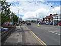
Image Listing (38 Images Found)
Images are licensed for reuse under creativecommons.org/licenses/by-sa/2.0
Image
Details
Distance
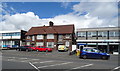
1
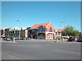
Bingo Hall
Leisure facility in the centre of Ellesmere Port.
Image: © Dennis Turner
Taken: 7 Aug 2005
0.01 miles
3
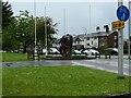
War memorial, council offices, Ellesmere Port
This is in memory of those who died in the Battle for Normandy, 1944
Image: © David Smith
Taken: 10 May 2023
0.06 miles
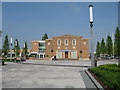
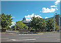
4
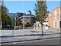
Ellesmere Port Town Centre
Looking across Civic Way towards the council offices.
Image: © Eirian Evans
Taken: 28 Sep 2011
0.06 miles
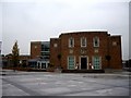
8
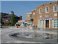
Fountain in front of Civic Hall
Fountain in front of Ellesmere Port Civic Hall with the Council Offices in the background.
Image: © Sue Adair
Taken: 3 May 2007
0.07 miles