IMAGES TAKEN NEAR TO
Girton Close, ELLESMERE PORT, CH65 5BJ
Introduction
This page details the photographs taken nearby to Girton Close, CH65 5BJ by members of the Geograph project.
The Geograph project started in 2005 with the aim of publishing, organising and preserving representative images for every square kilometre of Great Britain, Ireland and the Isle of Man.

There are currently over 7.5m images from over14,400 individuals and you can help contribute to the project by visiting https://www.geograph.org.uk
Image Map
Images are licensed for reuse under creativecommons.org/licenses/by-sa/2.0
Notes
- Clicking on the map will re-center to the selected point.
- The higher the marker number, the further away the image location is from the centre of the postcode.
Image Listing (7 Images Found)
Images are licensed for reuse under creativecommons.org/licenses/by-sa/2.0
Image
Details
Distance
1
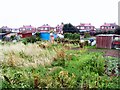
Digging in
Allotments in Wolverham, Ellesmere Port.
Image: © Roger May
Taken: 31 Aug 2005
0.11 miles
3
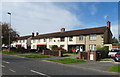
Roundabout and flats on Wolverham Road, Ellesmere Port
Image: © JThomas
Taken: 14 Sep 2019
0.23 miles
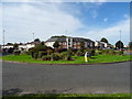
4
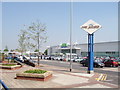
ASDA Ellesmere Port
The new ASDA in Ellesmere Port which opened in 2006, the old market hall has been demolished and the market moved to the more spacious former ASDA site.
Image: © Sue Adair
Taken: 3 May 2007
0.23 miles
5

Sign for the Cat public house, Ellesmere Port
See Image] for context.
Image: © JThomas
Taken: 14 Sep 2019
0.24 miles
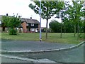
6
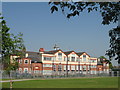
Cambridge Road School
The former school in Cambridge Road has now been converted into apartments.
Image: © Sue Adair
Taken: 3 May 2007
0.24 miles