IMAGES TAKEN NEAR TO
Malvern Avenue, ELLESMERE PORT, CH65 5AG
Introduction
This page details the photographs taken nearby to Malvern Avenue, CH65 5AG by members of the Geograph project.
The Geograph project started in 2005 with the aim of publishing, organising and preserving representative images for every square kilometre of Great Britain, Ireland and the Isle of Man.

There are currently over 7.5m images from over14,400 individuals and you can help contribute to the project by visiting https://www.geograph.org.uk
Image Map (Loading...)


Getting Data...Please wait
Leaflet Map data © OpenStreetMap
Images are licensed for reuse under creativecommons.org/licenses/by-sa/2.0
Notes
- Clicking on the map will re-center to the selected point.
- The higher the marker number, the further away the image location is from the centre of the postcode.
Image Listing (12 Images Found)
Images are licensed for reuse under creativecommons.org/licenses/by-sa/2.0
Image
Details
Distance
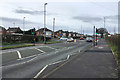
4
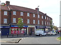
Post Office and shops on Wolverham Road, Ellesmere Port
Image: © JThomas
Taken: 14 Sep 2019
0.19 miles
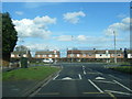
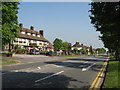
7
Roundabout and flats on Wolverham Road, Ellesmere Port
Image: © JThomas
Taken: 14 Sep 2019
0.21 miles
8
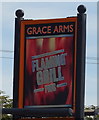
Sign for the Grace Arms, Ellesmere Port
See Image] for context.
Image: © JThomas
Taken: 14 Sep 2019
0.22 miles
9
The Grace Arms, Ellesmere Port
On Stanney Lane.
Image: © JThomas
Taken: 14 Sep 2019
0.22 miles
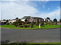
10
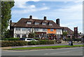
The Grace Arms, Stanney Lane
The Grace Arms, named after the family who owned Whitby Hall in the park opposite.
Image: © Sue Adair
Taken: 3 May 2007
0.22 miles