IMAGES TAKEN NEAR TO
Garth Road, ELLESMERE PORT, CH65 4ET
Introduction
This page details the photographs taken nearby to Garth Road, CH65 4ET by members of the Geograph project.
The Geograph project started in 2005 with the aim of publishing, organising and preserving representative images for every square kilometre of Great Britain, Ireland and the Isle of Man.

There are currently over 7.5m images from over14,400 individuals and you can help contribute to the project by visiting https://www.geograph.org.uk
Image Map (Loading...)


Getting Data...Please wait
Leaflet Map data © OpenStreetMap
Images are licensed for reuse under creativecommons.org/licenses/by-sa/2.0
Notes
- Clicking on the map will re-center to the selected point.
- The higher the marker number, the further away the image location is from the centre of the postcode.
Image Listing (4 Images Found)
Images are licensed for reuse under creativecommons.org/licenses/by-sa/2.0
Image
Details
Distance
1
Burmah-Castrol Refinery, Stanlow
Grid reference is still very approximate. If anybody knows better I would be delighted.
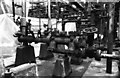
Worthington Simplex steam pump. Removed for preservation but subsequently scrapped. All this kit was in the open.
Image: © Chris Allen
Taken: 12 Nov 1983
0.21 miles
2
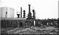
Burmah-Castrol Refinery, Stanlow
Grid ref is approximate as this was a large site and has been long cleared.
The picture shows the Dubs plant. This was basically all American kit with Worthington steam pumps and Erie-Ball rotative steam engines. Other areas had long rows of large steam pumps and there was a big power house with turbo-alternator sets and no working lights. This might be the first geograph inside an oil refinery.
Image: © Chris Allen
Taken: 12 Nov 1983
0.23 miles
3
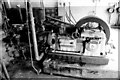
The Erie-Ball engine, Burmah-Castrol Refinery
An approximate grid reference. The site contained three of these American built horizontal single cylinder steam engines driving horizontal pumps. This or a similar machine is in store at Astley Green Colliery.
Image: © Chris Allen
Taken: 12 Nov 1983
0.23 miles
4

Stanlow Point and Stanlow Refinery from the air
With the Manchester Ship Canal running between the refinery and the open water of the River Mersey.
Image: © M J Richardson
Taken: 23 Nov 2017
0.25 miles