IMAGES TAKEN NEAR TO
Churchill Lane, ELLESMERE PORT, CH65 4DE
Introduction
This page details the photographs taken nearby to Churchill Lane, CH65 4DE by members of the Geograph project.
The Geograph project started in 2005 with the aim of publishing, organising and preserving representative images for every square kilometre of Great Britain, Ireland and the Isle of Man.

There are currently over 7.5m images from over14,400 individuals and you can help contribute to the project by visiting https://www.geograph.org.uk
Image Map (Loading...)


Getting Data...Please wait
Leaflet Map data © OpenStreetMap
Images are licensed for reuse under creativecommons.org/licenses/by-sa/2.0
Notes
- Clicking on the map will re-center to the selected point.
- The higher the marker number, the further away the image location is from the centre of the postcode.
Image Listing (24 Images Found)
Images are licensed for reuse under creativecommons.org/licenses/by-sa/2.0
Image
Details
Distance
1
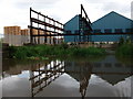
Former iron works, Ellesmere Port
There were still green fields south of the railway line until 1911, when buildings on this site first appear on Ordnance Survey maps. The 1937 OS plans call these buildings the 'Mersey Iron Works', and they appear little changed today.
Image: © John Brightley
Taken: 14 Jun 2010
0.19 miles
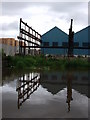
3
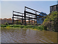
Former Ironworks, Shropshire Union Canal
The site of a former ironworks at the Stanlow winding hole on the Shropshire Union Canal near Ellesmere Port
Image: © David Dixon
Taken: 25 May 2012
0.19 miles
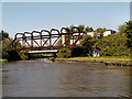
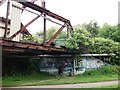
4
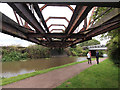
Disused Railway Bridge over the Shropshire Union Canal
Image: © Andy Beecroft
Taken: 6 Aug 2017
0.20 miles
5
Disused bridge over canal
Taken on the boat trip from the Waterways museum pleasure barge just turning back here after a short cruise on the canal.
Image: © Steve Fareham
Taken: 10 Oct 2007
0.20 miles
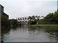
6
Shropshire Union Canal, Stanlow Works Access Bridge
The disused girder bridge near the railway line crossing the Shropshire Union Canal. (see http://www.canalplan.org.uk/gazetteer/qj4d CanalplanAC)
Image: © David Dixon
Taken: 25 May 2012
0.21 miles
7
Cromwell Road
Viewed from Whitby Road bridge.
Image: © Dennis Turner
Taken: 7 Aug 2005
0.21 miles
8
Disused Railway Bridge over the Shropshire Union Canal
Haven't a clue what the graffiti means - just hope it's not rude! Just wish the 'artist' could have done something more useful.
Image: © Andy Beecroft
Taken: 6 Aug 2017
0.21 miles
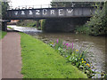
9
Stanlow Works Access Bridge (disused), Shropshire Union Canal
The name of this girder bridge is taken from the Canal Plan AC website.
Note the supposedly 'official' 'graffiti' with the name of the Prince's Trust Volunteers.
Image: © John Brightley
Taken: 14 Jun 2010
0.22 miles
10
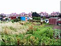
Digging in
Allotments in Wolverham, Ellesmere Port.
Image: © Roger May
Taken: 31 Aug 2005
0.22 miles