IMAGES TAKEN NEAR TO
Cromwell Road, ELLESMERE PORT, CH65 4BL
Introduction
This page details the photographs taken nearby to Cromwell Road, CH65 4BL by members of the Geograph project.
The Geograph project started in 2005 with the aim of publishing, organising and preserving representative images for every square kilometre of Great Britain, Ireland and the Isle of Man.

There are currently over 7.5m images from over14,400 individuals and you can help contribute to the project by visiting https://www.geograph.org.uk
Image Map (Loading...)


Getting Data...Please wait
Leaflet Map data © OpenStreetMap
Images are licensed for reuse under creativecommons.org/licenses/by-sa/2.0
Notes
- Clicking on the map will re-center to the selected point.
- The higher the marker number, the further away the image location is from the centre of the postcode.
Image Listing (49 Images Found)
Images are licensed for reuse under creativecommons.org/licenses/by-sa/2.0
Image
Details
Distance
1
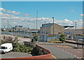
View from the bridge
View towards Cromwell Road
Image: © Dennis Turner
Taken: 7 Aug 2005
0.12 miles
2
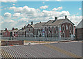
Cromwell Road
Viewed from Whitby Road bridge.
Image: © Dennis Turner
Taken: 7 Aug 2005
0.12 miles
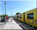
3
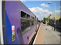
Waiting for the road
The 1534 to Helsby waits for the semaphore starting signal to be pulled off at Ellesmere Port. In contrast with the half hourly service to Liverpool, the line from here to Helsby gets only a handful of passenger trains (currently four per day each way Monday to Saturday), which exist primarily to transport workers to and from Stanlow oil refinery.
Image: © Richard Vince
Taken: 26 Jun 2010
0.14 miles
4
Cambridge Road School
The former school in Cambridge Road has now been converted into apartments.
Image: © Sue Adair
Taken: 3 May 2007
0.17 miles
5
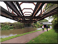
Disused Railway Bridge over the Shropshire Union Canal
Image: © Andy Beecroft
Taken: 6 Aug 2017
0.18 miles
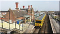
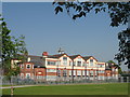
7
Ellesmere Port Station
The terminus for Merseyrail trains.
Image: © Gerald England
Taken: 14 May 2022
0.18 miles
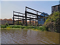
8
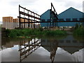
Former iron works, Ellesmere Port
There were still green fields south of the railway line until 1911, when buildings on this site first appear on Ordnance Survey maps. The 1937 OS plans call these buildings the 'Mersey Iron Works', and they appear little changed today.
Image: © John Brightley
Taken: 14 Jun 2010
0.18 miles
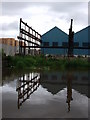
10
Former Ironworks, Shropshire Union Canal
The site of a former ironworks at the Stanlow winding hole on the Shropshire Union Canal near Ellesmere Port
Image: © David Dixon
Taken: 25 May 2012
0.18 miles