IMAGES TAKEN NEAR TO
Oil Sites Road, ELLESMERE PORT, CH65 4BE
Introduction
This page details the photographs taken nearby to Oil Sites Road, CH65 4BE by members of the Geograph project.
The Geograph project started in 2005 with the aim of publishing, organising and preserving representative images for every square kilometre of Great Britain, Ireland and the Isle of Man.

There are currently over 7.5m images from over14,400 individuals and you can help contribute to the project by visiting https://www.geograph.org.uk
Image Map (13 Images)


Getting Data...Please wait
Leaflet Map data © OpenStreetMap
Images are licensed for reuse under creativecommons.org/licenses/by-sa/2.0
Notes
- Clicking on the map will re-center to the selected point.
- The higher the marker number, the further away the image location is from the centre of the postcode.
Image Listing (13 Images Found)
Images are licensed for reuse under creativecommons.org/licenses/by-sa/2.0
Image
Details
Distance
1
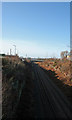
Parallel Lines
Railway line through cutting at Stanlow towards Ellesmere Port.
Image: © J Scott
Taken: 6 Feb 2008
0.06 miles
2

Stanlow Refinery
Between the A5117 and railway line from Helsby to Birkenhead on the left, and the Manchester Ship Canal and the River Mersey on the right.
Image: © M J Richardson
Taken: 23 Nov 2017
0.08 miles
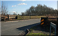
4
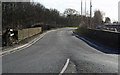
Railway Bridge
Road South from Ince towards Elton crossing the railway line from Helsby towards Ellesmere Port.
Image: © J Scott
Taken: 6 Feb 2008
0.16 miles
5
Bridge Wall
The Pool Lane continues over railway bridge towards the village of Elton.
Image: © J Scott
Taken: 6 Feb 2008
0.16 miles
6
Pool Lane Bridge
Road bridge over Helsby to Ellesmere Port railway.
Image: © J Scott
Taken: 6 Feb 2008
0.16 miles
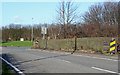
7
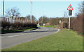
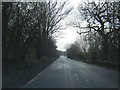
Road To Ince
The minor road curves towards roundabout that leads to Ince.
Image: © J Scott
Taken: 6 Feb 2008
0.17 miles
8

Benches & footpath on top of the mound, Ince
Image: © John Lord
Taken: 5 Dec 2009
0.18 miles
9
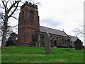
St. James Church, Ince
St James Church, built of red Triassic sandstone, occupies the highest point in the village. The stone was quarried in nearby Manley as the local pebble beds were not considered suitable for large scale construction.
Image: © Ian Nadin
Taken: 14 Dec 2006
0.20 miles