IMAGES TAKEN NEAR TO
Morland Avenue, NESTON, CH64 9RP
Introduction
This page details the photographs taken nearby to Morland Avenue, CH64 9RP by members of the Geograph project.
The Geograph project started in 2005 with the aim of publishing, organising and preserving representative images for every square kilometre of Great Britain, Ireland and the Isle of Man.

There are currently over 7.5m images from over14,400 individuals and you can help contribute to the project by visiting https://www.geograph.org.uk
Image Map (Loading...)


Getting Data...Please wait
Leaflet Map data © OpenStreetMap
Images are licensed for reuse under creativecommons.org/licenses/by-sa/2.0
Notes
- Clicking on the map will re-center to the selected point.
- The higher the marker number, the further away the image location is from the centre of the postcode.
Image Listing (14 Images Found)
Images are licensed for reuse under creativecommons.org/licenses/by-sa/2.0
Image
Details
Distance
1
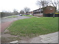
Neston (South) railway station (site)
Opened in 1866 by the Birkenhead Joint Railway on the line from Hooton to West Kirby, this station closed in 1962. View east towards Hooton.
Image: © Nigel Thompson
Taken: 21 Mar 2011
0.12 miles
2
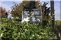
Old Road Sign on Station Road, Neston
This old road sign on Station Road which I think is a crossroads warning, is now being slowly engulfed by a garden hedge.
Image: © Jeff Buck
Taken: 26 Oct 2016
0.12 miles
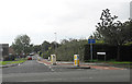
4
Station Road/Wirral Way, Neston
The Wirral Way following the course of the old Birkenhead Railway along Station Road at Neston.
Wikipedia https://en.wikipedia.org/wiki/Wirral_Country_Park
Image: © Jeff Buck
Taken: 26 Oct 2016
0.16 miles
5
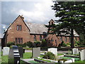
St Winefride's Church - Little Neston
St. Winefride's RC Church in Burton Road, Little Neston, built in 1843.
Image: © Sue Adair
Taken: 21 Jul 2010
0.16 miles
6
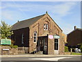
Neston Methodist Church
Little Neston Methodist Church on Mellock Lane. The Church was built in 1872 as a Primitive Methodist Chapel. Records show that the church buildings and furnishings cost £645, a considerable sum compared to the average farmworkers annual salary of £39.
Image: © Sue Adair
Taken: 3 Jun 2006
0.17 miles
7
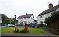
Houses on Burton Road, Neston
Showing position of Postbox No. CH64 386.
Image: © JThomas
Taken: 25 May 2019
0.18 miles
8
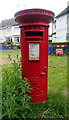
Elizabeth II postbox on Burton Road, Neston
Postbox No. CH64 386.
Image: © JThomas
Taken: 25 May 2019
0.19 miles
9
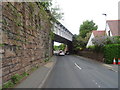
Railway bridge over Burton Road, Little Neston
Looking north west.
Image: © JThomas
Taken: 25 May 2019
0.19 miles
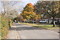
10
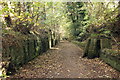
The Wirral Way and Wirral Circular Trail
The Wirral Way and Wirral Circular Trail heading east away from Neston through the Neston cutting.
Wikipedia https://en.wikipedia.org/wiki/Wirral_Country_Park
Image: © Jeff Buck
Taken: 26 Oct 2016
0.20 miles