IMAGES TAKEN NEAR TO
Raby Park Road, NESTON, CH64 9FX
Introduction
This page details the photographs taken nearby to Raby Park Road, CH64 9FX by members of the Geograph project.
The Geograph project started in 2005 with the aim of publishing, organising and preserving representative images for every square kilometre of Great Britain, Ireland and the Isle of Man.

There are currently over 7.5m images from over14,400 individuals and you can help contribute to the project by visiting https://www.geograph.org.uk
Image Map (Loading...)


Getting Data...Please wait
Leaflet Map data © OpenStreetMap
Images are licensed for reuse under creativecommons.org/licenses/by-sa/2.0
Notes
- Clicking on the map will re-center to the selected point.
- The higher the marker number, the further away the image location is from the centre of the postcode.
Image Listing (4 Images Found)
Images are licensed for reuse under creativecommons.org/licenses/by-sa/2.0
Image
Details
Distance
1
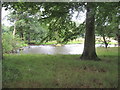
Pond near Neston
Taken from the footpath. I do not think this is used for fishing and it is on private farmland.
Image: © David Quinn
Taken: 26 Jul 2009
0.11 miles
2
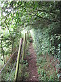
Footpath between Neston and Chester High Road
A good quality footpath, which for most of its path is sandwiched between a fence and a hedge like in the photo.
Image: © David Quinn
Taken: 26 Jul 2009
0.12 miles
3
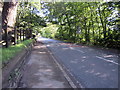
The A540 (Chester High Road) near Neston
The A540 (Chester High Road) to the northeast of Neston.
Image: © Jeff Buck
Taken: 30 Aug 2017
0.21 miles
4
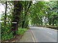
Chester High Road (A540), Hinderton
Towards Hoylake.
Image: © JThomas
Taken: 15 Jun 2019
0.23 miles