IMAGES TAKEN NEAR TO
Neston Road, NESTON, CH64 7TL
Introduction
This page details the photographs taken nearby to Neston Road, CH64 7TL by members of the Geograph project.
The Geograph project started in 2005 with the aim of publishing, organising and preserving representative images for every square kilometre of Great Britain, Ireland and the Isle of Man.

There are currently over 7.5m images from over14,400 individuals and you can help contribute to the project by visiting https://www.geograph.org.uk
Image Map
Images are licensed for reuse under creativecommons.org/licenses/by-sa/2.0
Notes
- Clicking on the map will re-center to the selected point.
- The higher the marker number, the further away the image location is from the centre of the postcode.
Image Listing (11 Images Found)
Images are licensed for reuse under creativecommons.org/licenses/by-sa/2.0
Image
Details
Distance
1
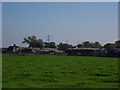
Westwood Farm
Westwood farm buildings viewed across fields from Parkgate Lane.
Image: © J Scott
Taken: 12 Oct 2010
0.05 miles
2
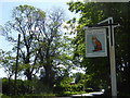
The Red Fox
Sign for the public house on Liverpool Road.
Image: © Eirian Evans
Taken: 14 May 2016
0.07 miles
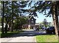
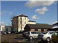
3
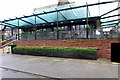
Glass covered terrace at the Grange Country Club
Image: © Philip Jeffrey
Taken: 17 Dec 2012
0.10 miles
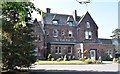
4
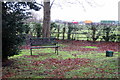
Country seat at the Grange Country Club
Image: © Philip Jeffrey
Taken: 17 Dec 2012
0.10 miles
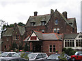
6
The Red Fox
Red sandstone building, commissioned by Lord Leverhulme, but has since passed through many hands before becoming a large restaurant and public house.
Image: © Eirian Evans
Taken: 14 May 2016
0.10 miles
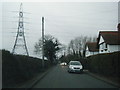
10
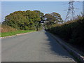
Straight Lane
Parkgate Lane route from Chester High Road (A540) to Neston Road (B5136).
Image: © J Scott
Taken: 12 Oct 2010
0.22 miles