IMAGES TAKEN NEAR TO
Greenway, NESTON, CH64 6XG
Introduction
This page details the photographs taken nearby to Greenway, CH64 6XG by members of the Geograph project.
The Geograph project started in 2005 with the aim of publishing, organising and preserving representative images for every square kilometre of Great Britain, Ireland and the Isle of Man.

There are currently over 7.5m images from over14,400 individuals and you can help contribute to the project by visiting https://www.geograph.org.uk
Image Map (Loading...)


Getting Data...Please wait
Leaflet Map data © OpenStreetMap
Images are licensed for reuse under creativecommons.org/licenses/by-sa/2.0
Notes
- Clicking on the map will re-center to the selected point.
- The higher the marker number, the further away the image location is from the centre of the postcode.
Image Listing (40 Images Found)
Images are licensed for reuse under creativecommons.org/licenses/by-sa/2.0
Image
Details
Distance
2
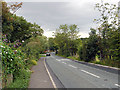
Boathouse Lane, Parkgate
Looking south west on the B5135.
Image: © JThomas
Taken: 25 May 2019
0.08 miles
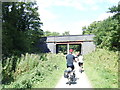
3
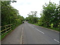
The Wirral Way at Parkgate
Heading north along the Wirral Way at Parkgate. The road bridge carries the B5135 (Boathouse Lane). The Wirral Way follows the track bed of part of the former Birkenhead Railway route from West Kirby to Hooton.
Wikipedia https://en.wikipedia.org/wiki/Wirral_Country_Park
Image: © Jeff Buck
Taken: 6 Jun 2016
0.12 miles
4
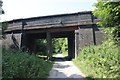
Boathouse Lane bridge over National Cycle Route 56
Looking north west on a disused railway.
Image: © JThomas
Taken: 25 May 2019
0.12 miles
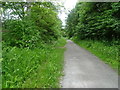
6
The Wirral Way at Parkgate
Looking south along the Wirral Way at Parkgate. The Wirral Way follows the track bed of part of the former Birkenhead Railway route from West Kirby to Hooton.
Wikipedia https://en.wikipedia.org/wiki/Wirral_Country_Park
Image: © Jeff Buck
Taken: 6 Jun 2016
0.13 miles

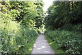
8
The Wirral Way
Looking north west on a disused railway.
Image: © JThomas
Taken: 25 May 2019
0.14 miles
9
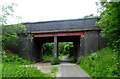
Bridge over the Wirral Way
This bridge carries Boathouse Lane, the B5135 in to Parkgate.
Image: © Eric Marsh
Taken: 28 Oct 2016
0.16 miles
10

Cottages, Parkgate
The two cottages, Pengwern and Sawyer's Cottage, are two of the earliest surviving houses in Parkgate, built pre-1700. One owner of Pengwern was a wealthy mariner, Charles Salisbury, a captain and ship owner.
Image: © Eirian Evans
Taken: 16 Feb 2019
0.17 miles