IMAGES TAKEN NEAR TO
Brooklands Road, NESTON, CH64 6SN
Introduction
This page details the photographs taken nearby to Brooklands Road, CH64 6SN by members of the Geograph project.
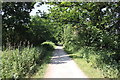
The Geograph project started in 2005 with the aim of publishing, organising and preserving representative images for every square kilometre of Great Britain, Ireland and the Isle of Man.

There are currently over 7.5m images from over14,400 individuals and you can help contribute to the project by visiting https://www.geograph.org.uk
Image Map (Loading...)


Getting Data...Please wait
Leaflet Map data © OpenStreetMap
Images are licensed for reuse under creativecommons.org/licenses/by-sa/2.0
Notes
- Clicking on the map will re-center to the selected point.
- The higher the marker number, the further away the image location is from the centre of the postcode.
Image Listing (55 Images Found)
Images are licensed for reuse under creativecommons.org/licenses/by-sa/2.0
Image
Details
Distance
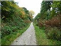
1
Disused railway bridge (now the Wirral Way) at Parkgate
Image: © John Slater
Taken: 11 Jun 2016
0.06 miles
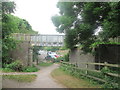
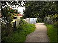
2
Wirral Way crosses Brooklands Road, Parkgate
Image: © Colin Pyle
Taken: 5 Aug 2011
0.07 miles
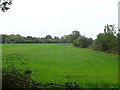
3
Parkgate - footpath to Wood Lane
Parkgate: view along footpath from Brooklands Road to Wood Lane, seen from the bridge carrying the Wirral Way over it at the end of Brooklands Road.
Image: © Mike Harris
Taken: 29 Oct 2006
0.07 miles
4
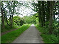
National Cycle Route 56
Looking north on a disused railway.
Image: © JThomas
Taken: 25 May 2019
0.08 miles
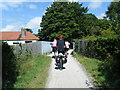
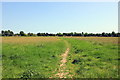
7
The Wirral Way
The path leads into Parkgate.
Image: © Eric Marsh
Taken: 28 Oct 2016
0.10 miles
8
Park Fields, Parkgate
Park Fields is an area of 41 acres used by the local and wider community and includes three football pitches, gymkhanas and areas for jogging, exercising, dog-walking, kite-flying, bird-watching, family games and socialising.
Source: fieldsintrust.org
Image: © Jeff Buck
Taken: 6 Jun 2016
0.10 miles
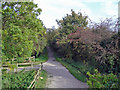
9
The Wirral Way at Parkgate
Heading north along the Wirral Way at Parkgate. The Wirral Way follows the track bed of part of the former Birkenhead Railway route from West Kirby to Hooton.
Wikipedia https://en.wikipedia.org/wiki/Wirral_Country_Park
Image: © Jeff Buck
Taken: 6 Jun 2016
0.12 miles
10
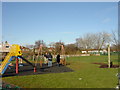
Ropewalk Children's Playground, Parkgate
Children's playground in Parkgate, photo taken from The Ropewalk, primary school in the background
Image: © Sue Adair
Taken: 4 Mar 2006
0.13 miles