IMAGES TAKEN NEAR TO
Mealors Weint, NESTON, CH64 6RS
Introduction
This page details the photographs taken nearby to Mealors Weint, CH64 6RS by members of the Geograph project.
The Geograph project started in 2005 with the aim of publishing, organising and preserving representative images for every square kilometre of Great Britain, Ireland and the Isle of Man.

There are currently over 7.5m images from over14,400 individuals and you can help contribute to the project by visiting https://www.geograph.org.uk
Image Map (Loading...)


Getting Data...Please wait
Leaflet Map data © OpenStreetMap
Images are licensed for reuse under creativecommons.org/licenses/by-sa/2.0
Notes
- Clicking on the map will re-center to the selected point.
- The higher the marker number, the further away the image location is from the centre of the postcode.
Image Listing (84 Images Found)
Images are licensed for reuse under creativecommons.org/licenses/by-sa/2.0
Image
Details
Distance
2

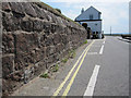
The Old Watch House
Leased by the HM Customs between 1799 and 1828 to accommodate their officers and keep watch on the local shipping.
Image: © Eirian Evans
Taken: 16 Feb 2019
0.04 miles
3
Nautical plant holder, Parkgate
An unusual plant pot on The Parade, Parkgate. Behind it is the Gayton Sands Nature Reserve
Image: © Matt Harrop
Taken: 17 Mar 2018
0.04 miles
4
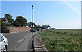
Looking south down The Parade at Neston
Image: © Eirian Evans
Taken: 12 Sep 2009
0.04 miles
5
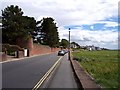
Decorative wall on road to Parkgate front
View South towards Parkgate
Image: © Raymond Knapman
Taken: 1 Aug 2008
0.04 miles
6
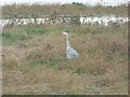
Heron at Parkgate
High tide brings a lot of food for these birds.
Image: © Eric Marsh
Taken: 28 Oct 2016
0.05 miles
7
Old stone wall and a bench mark in The Parade
This old stone wall is the property boundary for Deva Bank, and straight ahead, jutting out into the road, is The Watch House. There is a bench mark on the left hand side of the photo Image
Image: © John S Turner
Taken: 4 Jun 2011
0.05 miles
8
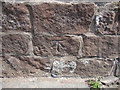
Bench mark alongside The Parade
This bench mark is on the old property boundary wall for Deva Bank in The Parade. The mark is recorded on the 1874-82 O.S. map levelled at 22.03 feet. See also Image and Bench Mark Database at http://www.bench-marks.org.uk/bm38221
Image: © John S Turner
Taken: 4 Jun 2011
0.05 miles
9
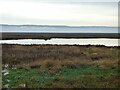
High tide at Parkgate
Looking across the Dee to Flint
Image: © Eric Marsh
Taken: 28 Oct 2016
0.06 miles
