IMAGES TAKEN NEAR TO
Station Road, NESTON, CH64 6QJ
Introduction
This page details the photographs taken nearby to Station Road, CH64 6QJ by members of the Geograph project.
The Geograph project started in 2005 with the aim of publishing, organising and preserving representative images for every square kilometre of Great Britain, Ireland and the Isle of Man.

There are currently over 7.5m images from over14,400 individuals and you can help contribute to the project by visiting https://www.geograph.org.uk
Image Map (Loading...)


Getting Data...Please wait
Leaflet Map data © OpenStreetMap
Images are licensed for reuse under creativecommons.org/licenses/by-sa/2.0
Notes
- Clicking on the map will re-center to the selected point.
- The higher the marker number, the further away the image location is from the centre of the postcode.
Image Listing (146 Images Found)
Images are licensed for reuse under creativecommons.org/licenses/by-sa/2.0
Image
Details
Distance
1
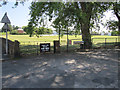
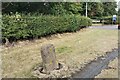
Manorial Road and Neston cricket ground
This is the west end of Manorial Road where it joins Station Road. In the background is Neston Cricket Club, which is over 100 years old http://nestoncricketclub.co.uk/default.aspx The old stone gatepost on the left has a bench mark Image
Image: © John S Turner
Taken: 3 Jun 2011
0.02 miles
2
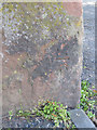
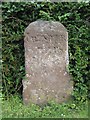
Bench mark in Station Road
This damaged bench mark is on the corner of Station Road and Manorial Road. Neston Cricket Club ground is behind it to the left. The mark is first recorded on the 1954 O.S. map. For a wider view see: Image
Benchmark Database: https://www.bench-marks.org.uk/bm38211
Image: © John S Turner
Taken: 3 Jun 2011
0.03 miles
3
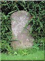
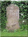
Old Milestone near Mostyn School House, Parkgate, Neston parish
Carved stone post by the driveway, in parish of NESTON (ELLESMERE PORT AND NESTON District), assumed to be from A540 at Mollington, now beside Grenfell Court, Mostyn House School, Station Road. Wirral stone, erected by the Chester, Neston & Woodside Ferry turnpike trust in the 18th century.
Inscription reads:-
CHESTER
(4) MILES
Milestone Society National ID: CH_CHWR04.
Image: © J Higgins
Taken: 1 Jul 2012
0.03 miles
4
Old Milestone by Mostyn House School, Parkgate, Wirral
Carved stone post by the driveway, in parish of NESTON (ELLESMERE PORT AND NESTON District), assumed to be from A540 at Puddington, now beside The Parade, Mostyn House School, Station Road. Wirral stone, erected by the Chester, Neston & Woodside Ferry turnpike trust in the 18th century.
Inscription reads:- : CHESTER / 8 / MILES : : WILLASTON :
Milestone Society National ID: CH_CHWR08.
Image: © J Higgins
Taken: 1 Jul 2012
0.03 miles
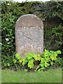
5
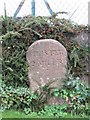
Old Milestone in Grenfell Court, Parkgate
Carved stone post by the driveway, in parish of Neston (Ellesmere Port and Neston District), assumed to be from A540 at Mollington, now beside Grenfell Court, formerly Mostyn House School, Station Road. Wirral stone, erected by the Chester, Neston & Woodside Ferry turnpike trust in the 18th century.
Inscription reads:-
: CHESTER / 3 MILES : : MOLLINGTON :
Milestone Society National ID: CH_CHWR03
Image: © J Higgins
Taken: 1 Jul 2012
0.03 miles
6
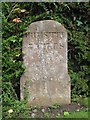
Old Milestone by Grenfell Park, Neston
Carved stone post by the driveway, in parish of Neston (Ellesmere Port and Neston District), assumed to be from A540 at Neston, now near The Parade, Mostyn House School, Station Road. Wirral stone, erected by the Chester, Neston & Woodside Ferry turnpike trust in the 18th century.
Inscription reads:-
CHESTER
9 MILES
Milestone Society National ID: CH_CHWR09
Image: © J Higgins
Taken: 1 Jul 2012
0.03 miles
7
Old Milestone near Mostyn House School, Parkgate, Neston parish
Carved stone post by the driveway, in parish of NESTON (ELLESMERE PORT AND NESTON District), assumed to be from A540 at Puddington, now beside Grenfell Court, Mostyn House School, Parkgate. Wirral stone, erected by the Chester, Neston & Woodside Ferry turnpike trust in the 18th century.
Inscription reads:-
CHESTER
7 MILES
PUDDINGTON
Milestone Society National ID: CH_CHWR07.
Image: © J Higgins
Taken: 1 Jul 2012
0.04 miles
9
Old Milestone near Mostyn House School, Parkgate, Neston parish
Carved stone post by the driveway, in parish of NESTON (ELLESMERE PORT AND NESTON District), assumed to be from A540 at Puddington, now beside Grenfell Court, Mostyn House School, Parkgate. Wirral stone, erected by the Chester, Neston & Woodside Ferry turnpike trust in the 18th century.
Inscription reads:-
CHESTER
7 MILES
PUDDINGTON
Milestone Society National ID: CH_CHWR07
Image: © Phil Pritchard
Taken: 9 Jun 2020
0.04 miles
10
Old Milestone by The Parade, Neston School
Carved stone post by the driveway, in parish of NESTON (ELLESMERE PORT AND NESTON District), assumed to be from the A540 at Saughall, now beside The Parade, Mostyn House School, Station Road. Wirral stone, erected by the Chester, Neston & Woodside Ferry turnpike trust in the 18th century.
Inscription reads:-
CHESTER
5 MILES
Milestone Society National ID: CH_CHWR05.
Image: © J Higgins
Taken: 1 Jul 2012
0.04 miles