IMAGES TAKEN NEAR TO
Rockfarm Drive, NESTON, CH64 4DY
Introduction
This page details the photographs taken nearby to Rockfarm Drive, CH64 4DY by members of the Geograph project.
The Geograph project started in 2005 with the aim of publishing, organising and preserving representative images for every square kilometre of Great Britain, Ireland and the Isle of Man.

There are currently over 7.5m images from over14,400 individuals and you can help contribute to the project by visiting https://www.geograph.org.uk
Image Map (Loading...)


Getting Data...Please wait
Leaflet Map data © OpenStreetMap
Images are licensed for reuse under creativecommons.org/licenses/by-sa/2.0
Notes
- Clicking on the map will re-center to the selected point.
- The higher the marker number, the further away the image location is from the centre of the postcode.
Image Listing (2 Images Found)
Images are licensed for reuse under creativecommons.org/licenses/by-sa/2.0
Image
Details
Distance
2
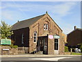
Neston Methodist Church
Little Neston Methodist Church on Mellock Lane. The Church was built in 1872 as a Primitive Methodist Chapel. Records show that the church buildings and furnishings cost £645, a considerable sum compared to the average farmworkers annual salary of £39.
Image: © Sue Adair
Taken: 3 Jun 2006
0.22 miles