IMAGES TAKEN NEAR TO
Boathouse Lane, NESTON, CH64 3SZ
Introduction
This page details the photographs taken nearby to Boathouse Lane, CH64 3SZ by members of the Geograph project.
The Geograph project started in 2005 with the aim of publishing, organising and preserving representative images for every square kilometre of Great Britain, Ireland and the Isle of Man.

There are currently over 7.5m images from over14,400 individuals and you can help contribute to the project by visiting https://www.geograph.org.uk
Image Map (Loading...)


Getting Data...Please wait
Leaflet Map data © OpenStreetMap
Images are licensed for reuse under creativecommons.org/licenses/by-sa/2.0
Notes
- Clicking on the map will re-center to the selected point.
- The higher the marker number, the further away the image location is from the centre of the postcode.
Image Listing (5 Images Found)
Images are licensed for reuse under creativecommons.org/licenses/by-sa/2.0
Image
Details
Distance
2
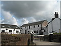
Backwood Farm Mews
Backwood Farm Mews, sandstone cottages built around 1700.
Image: © Sue Adair
Taken: 29 Mar 2007
0.01 miles
3
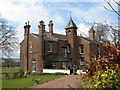
Backwood Hall
Backwood Hall near Parkgate.
Image: © Sue Adair
Taken: 29 Mar 2007
0.06 miles
4
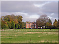
Parkgate - Backwood Hall
Parkgate: view of Backwood Hall from the embankment beside the Wirral Way.
Image: © Mike Harris
Taken: 29 Oct 2006
0.10 miles
5

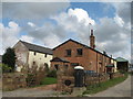
Track from Gayton Farm Road
Late autumn on the track from Gayton Farm Road to Backwood Hall.
Image: © Sue Adair
Taken: 18 Nov 2012
0.24 miles