IMAGES TAKEN NEAR TO
Benty Heath Lane, NESTON, CH64 1SB
Introduction
This page details the photographs taken nearby to Benty Heath Lane, CH64 1SB by members of the Geograph project.
The Geograph project started in 2005 with the aim of publishing, organising and preserving representative images for every square kilometre of Great Britain, Ireland and the Isle of Man.

There are currently over 7.5m images from over14,400 individuals and you can help contribute to the project by visiting https://www.geograph.org.uk
Image Map (Loading...)


Getting Data...Please wait
Leaflet Map data © OpenStreetMap
Images are licensed for reuse under creativecommons.org/licenses/by-sa/2.0
Notes
- Clicking on the map will re-center to the selected point.
- The higher the marker number, the further away the image location is from the centre of the postcode.
Image Listing (13 Images Found)
Images are licensed for reuse under creativecommons.org/licenses/by-sa/2.0
Image
Details
Distance
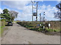
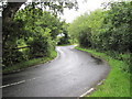
1
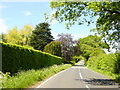
Benty Heath Lane, looking towards Raby House Farm
Image: © Sue Adair
Taken: 3 Jun 2006
0.10 miles
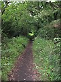
2
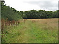
Footpath north of Willaston
The last field before joining the Street Hey Bridleway.
Image: © David Quinn
Taken: 26 Jul 2009
0.11 miles
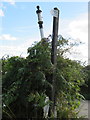
4
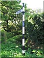
Old Direction Sign - Signpost by Gipsy Corner, Benty Heath Lane, Neston Parish
Ball finial - 1 arm; Wirral Footpath post by the UC road, in parish of Neston (Ellesmere Port And Neston District), Benty Heath Lane at start of path to Willaston.
Surveyed
Milestone Society National ID: CH_SJ3379B
Image: © Milestone Society
Taken: Unknown
0.14 miles
5
Waymarker on Benty Heath Lane
The track leads across the M53 to Hargrave House Farm
Image: © Raymond Knapman
Taken: 9 Mar 2017
0.14 miles
6
Old Direction Sign - Signpost by Benty Heath Lane, Willaston
Ball finial - 1 arm missing; Wirral Footpath post by the UC road, in parish of Bebington (Wirral District), Benty Heath Lane at start of path, Willaston.
Merseyside HER recorded.
https://www.heritagegateway.org.uk/Gateway/Results_Single.aspx?uid=3314371&resourceID=1970
Surveyed
Milestone Society National ID: CH_SJ3379A
Image: © John S Turner
Taken: 17 Sep 2016
0.14 miles
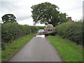
7
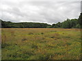
Lane to Hargrave House Farm
Lane to Hargrave House Farm seen from Benty Heath Lane.
Image: © Jeff Buck
Taken: 30 Aug 2017
0.15 miles
8
Private Drive from Hargrave House Farm
Also making up part of a footpath from Raby Mere.
Image: © David Quinn
Taken: 26 Jul 2009
0.16 miles
10
Bridleway near Willaston
A short bridleway between Street Hey Lane and Benty Heath Lane.
Image: © David Quinn
Taken: 3 Jul 2009
0.19 miles