IMAGES TAKEN NEAR TO
Wirral Close, WIRRAL, CH63 3BJ
Introduction
This page details the photographs taken nearby to Wirral Close, CH63 3BJ by members of the Geograph project.
The Geograph project started in 2005 with the aim of publishing, organising and preserving representative images for every square kilometre of Great Britain, Ireland and the Isle of Man.

There are currently over 7.5m images from over14,400 individuals and you can help contribute to the project by visiting https://www.geograph.org.uk
Image Map
Images are licensed for reuse under creativecommons.org/licenses/by-sa/2.0
Notes
- Clicking on the map will re-center to the selected point.
- The higher the marker number, the further away the image location is from the centre of the postcode.
Image Listing (4 Images Found)
Images are licensed for reuse under creativecommons.org/licenses/by-sa/2.0
Image
Details
Distance
1
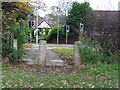
Restricted Path
Entrance to footpath from Brimstage Road, to Brackenwood Road.
Image: © J Scott
Taken: 10 Nov 2010
0.06 miles
2
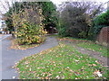
Cut Through
Footpath from Clatterbridge Road through to Stevenson Drive.
Image: © J Scott
Taken: 10 Nov 2010
0.10 miles
3
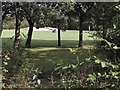
In the Rough
The south-easterly part of Brackenwood golfcourse at Bebington on the Wirral.
Image: © Roger May
Taken: 30 Aug 2005
0.12 miles
4
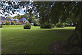
A small patch of open space on the corner of Cross Lane and Stanton Road
Image: © Ian Greig
Taken: 1 Sep 2017
0.24 miles