IMAGES TAKEN NEAR TO
Cedar Avenue, WIRRAL, CH63 2NG
Introduction
This page details the photographs taken nearby to Cedar Avenue, CH63 2NG by members of the Geograph project.
The Geograph project started in 2005 with the aim of publishing, organising and preserving representative images for every square kilometre of Great Britain, Ireland and the Isle of Man.

There are currently over 7.5m images from over14,400 individuals and you can help contribute to the project by visiting https://www.geograph.org.uk
Image Map (Loading...)


Getting Data...Please wait
Leaflet Map data © OpenStreetMap
Images are licensed for reuse under creativecommons.org/licenses/by-sa/2.0
Notes
- Clicking on the map will re-center to the selected point.
- The higher the marker number, the further away the image location is from the centre of the postcode.
Image Listing (7 Images Found)
Images are licensed for reuse under creativecommons.org/licenses/by-sa/2.0
Image
Details
Distance
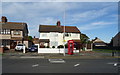
1
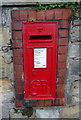
George V postbox on Heath Road, Bebington
Postbox No. CH63 437.
See Image] for context.
Image: © JThomas
Taken: 14 Sep 2019
0.18 miles
2
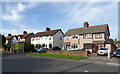
Heath Road, Bebington
Showing position of Postbox No. CH63 437.
See Image] for postbox.
Image: © JThomas
Taken: 14 Sep 2019
0.18 miles
3
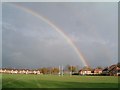
Over the posts!
This rainbow was converted whilst walking past the Wirral Grammar School for Boys rugby fields, the shot taken from Stanton Road, Bebington
Image: © Peter Bruffell
Taken: 13 Nov 2005
0.19 miles
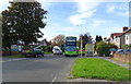
5
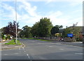
Bus stop and shelter on Heath Road, Bebington
Image: © JThomas
Taken: 14 Sep 2019
0.21 miles
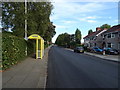
6
Bus stop and shelter on Teehey Lane, Bebington
Image: © JThomas
Taken: 14 Sep 2019
0.22 miles