IMAGES TAKEN NEAR TO
The Folds, WIRRAL, CH63 1JU
Introduction
This page details the photographs taken nearby to The Folds, CH63 1JU by members of the Geograph project.
The Geograph project started in 2005 with the aim of publishing, organising and preserving representative images for every square kilometre of Great Britain, Ireland and the Isle of Man.

There are currently over 7.5m images from over14,400 individuals and you can help contribute to the project by visiting https://www.geograph.org.uk
Image Map
Images are licensed for reuse under creativecommons.org/licenses/by-sa/2.0
Notes
- Clicking on the map will re-center to the selected point.
- The higher the marker number, the further away the image location is from the centre of the postcode.
Image Listing (56 Images Found)
Images are licensed for reuse under creativecommons.org/licenses/by-sa/2.0
Image
Details
Distance
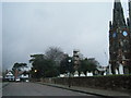
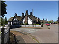
1
The Folds at Thornton Hough
Viewed from Neston Road
Image: © Raymond Knapman
Taken: 4 Apr 2014
0.02 miles
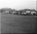
3
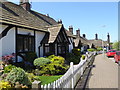
Row of cottages on Raby Road
Picture-postcard cottages in pretty Thornton Hough
Image: © Eirian Evans
Taken: 14 May 2016
0.03 miles
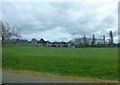
5
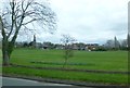
The recreation ground at Thornton Hough
Image: © Raymond Knapman
Taken: 4 Apr 2014
0.04 miles
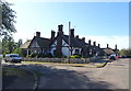
6
Cottages, Thornton Hough
Grade II listed timber-framed cottages on Raby Road.
Image: © Eirian Evans
Taken: 14 May 2016
0.04 miles
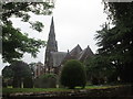
7
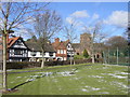
Thornton Hough
Cottages and St George's church from the village green at Thornton Hough
Image: © Sue Adair
Taken: 4 Mar 2006
0.04 miles