IMAGES TAKEN NEAR TO
Blakeley Road, WIRRAL, CH63 0NB
Introduction
This page details the photographs taken nearby to Blakeley Road, CH63 0NB by members of the Geograph project.
The Geograph project started in 2005 with the aim of publishing, organising and preserving representative images for every square kilometre of Great Britain, Ireland and the Isle of Man.

There are currently over 7.5m images from over14,400 individuals and you can help contribute to the project by visiting https://www.geograph.org.uk
Image Map (Loading...)


Getting Data...Please wait
Leaflet Map data © OpenStreetMap
Images are licensed for reuse under creativecommons.org/licenses/by-sa/2.0
Notes
- Clicking on the map will re-center to the selected point.
- The higher the marker number, the further away the image location is from the centre of the postcode.
Image Listing (2 Images Found)
Images are licensed for reuse under creativecommons.org/licenses/by-sa/2.0
Image
Details
Distance
1
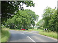
Junction of Raby Hall Rd with Raby Mere Rd
The junction of Raby Hall Rd with Raby Mere Rd is no more than a bend since the construction of the M53. Raby Mere Road is now a dead end, other than a motorway bridge and a bungalow hidden by trees, there is very little else in this square!
Image: © Sue Adair
Taken: 2 Jul 2006
0.04 miles
2
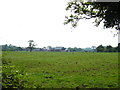
Raby Hall Farm from Raby Hall Road
Raby Hall Farm taken across the fields from Raby Hall Road.
Image: © Sue Adair
Taken: 2 Jul 2006
0.16 miles