IMAGES TAKEN NEAR TO
Thornton Common Road, WIRRAL, CH63 0LT
Introduction
This page details the photographs taken nearby to Thornton Common Road, CH63 0LT by members of the Geograph project.
The Geograph project started in 2005 with the aim of publishing, organising and preserving representative images for every square kilometre of Great Britain, Ireland and the Isle of Man.

There are currently over 7.5m images from over14,400 individuals and you can help contribute to the project by visiting https://www.geograph.org.uk
Image Map (Loading...)


Getting Data...Please wait
Leaflet Map data © OpenStreetMap
Images are licensed for reuse under creativecommons.org/licenses/by-sa/2.0
Notes
- Clicking on the map will re-center to the selected point.
- The higher the marker number, the further away the image location is from the centre of the postcode.
Image Listing (10 Images Found)
Images are licensed for reuse under creativecommons.org/licenses/by-sa/2.0
Image
Details
Distance
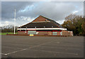
2
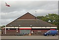
Wirral Rugby Club clubhouse
Wirral Rugby Club clubhouse.
Image: © Jeff Buck
Taken: 12 Oct 2017
0.09 miles
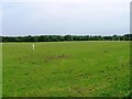
3
Rugby ground from Clatterbridge Road
Image: © Raymond Knapman
Taken: 4 Apr 2014
0.09 miles
4
Shutter Up
The rugby club of Thornton Hough, Thornton Common Road.
Image: © J Scott
Taken: 11 Nov 2010
0.09 miles
5
No Game Today
The rugby club of Thornton Hough, Thornton Common Road.
Image: © J Scott
Taken: 11 Nov 2010
0.09 miles
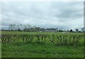
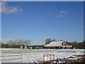
6
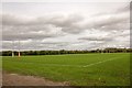
The playing field at Wirral Rugby Club
Looking northeast across the playing field from Thornton Common Road.
Image: © Jeff Buck
Taken: 12 Oct 2017
0.12 miles
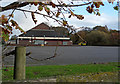
8
Wirral Rugby and Cricket Club
Wirral Rugby and Cricket Club pavilion.
Image: © Sue Adair
Taken: 4 Mar 2006
0.18 miles
9
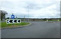
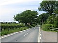
Roundabout on Thornton Common Road
Near Clatterbridge Hospital
Image: © Raymond Knapman
Taken: 4 Apr 2014
0.19 miles