IMAGES TAKEN NEAR TO
Barrymore Way, WIRRAL, CH63 0HN
Introduction
This page details the photographs taken nearby to Barrymore Way, CH63 0HN by members of the Geograph project.
The Geograph project started in 2005 with the aim of publishing, organising and preserving representative images for every square kilometre of Great Britain, Ireland and the Isle of Man.

There are currently over 7.5m images from over14,400 individuals and you can help contribute to the project by visiting https://www.geograph.org.uk
Image Map (Loading...)


Getting Data...Please wait
Leaflet Map data © OpenStreetMap
Images are licensed for reuse under creativecommons.org/licenses/by-sa/2.0
Notes
- Clicking on the map will re-center to the selected point.
- The higher the marker number, the further away the image location is from the centre of the postcode.
Image Listing (11 Images Found)
Images are licensed for reuse under creativecommons.org/licenses/by-sa/2.0
Image
Details
Distance
1
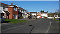
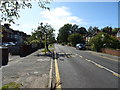
Aldford Close
Private housing stock in this quiet suburb.
Image: © Peter Mackenzie
Taken: 15 Mar 2017
0.09 miles
8
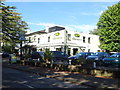
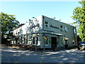
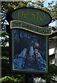
The Dibbinsdale Inn, Bromborough
On Dibbinsdale Road.
Image: © JThomas
Taken: 14 Sep 2019
0.21 miles
9
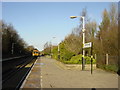
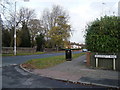
Bromborough Station
Chester train approaching Bromborough Station.
Image: © Sue Adair
Taken: 11 Jan 2006
0.21 miles