IMAGES TAKEN NEAR TO
Athol Close, WIRRAL, CH62 8DS
Introduction
This page details the photographs taken nearby to Athol Close, CH62 8DS by members of the Geograph project.
The Geograph project started in 2005 with the aim of publishing, organising and preserving representative images for every square kilometre of Great Britain, Ireland and the Isle of Man.

There are currently over 7.5m images from over14,400 individuals and you can help contribute to the project by visiting https://www.geograph.org.uk
Image Map (Loading...)


Getting Data...Please wait
Leaflet Map data © OpenStreetMap
Images are licensed for reuse under creativecommons.org/licenses/by-sa/2.0
Notes
- Clicking on the map will re-center to the selected point.
- The higher the marker number, the further away the image location is from the centre of the postcode.
Image Listing (11 Images Found)
Images are licensed for reuse under creativecommons.org/licenses/by-sa/2.0
Image
Details
Distance
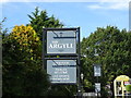
5
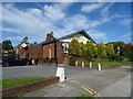
The Argyll Bar & Carvery, Eastham
On Plymyard Avenue.
Image: © JThomas
Taken: 14 Sep 2019
0.15 miles
8
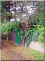
Green Door
Electricity substation alongside footpath between Hillary Road and Woodlea Close
Image: © J Scott
Taken: 22 Nov 2007
0.19 miles
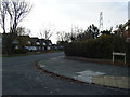
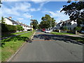
10
Hang a left
Junction of Sutherland Drive and Plymyard Avenue, Eastham.
Image: © J Scott
Taken: 10 Nov 2010
0.24 miles