IMAGES TAKEN NEAR TO
New Chester Road, WIRRAL, CH62 8BP
Introduction
This page details the photographs taken nearby to New Chester Road, CH62 8BP by members of the Geograph project.
The Geograph project started in 2005 with the aim of publishing, organising and preserving representative images for every square kilometre of Great Britain, Ireland and the Isle of Man.

There are currently over 7.5m images from over14,400 individuals and you can help contribute to the project by visiting https://www.geograph.org.uk
Image Map
Images are licensed for reuse under creativecommons.org/licenses/by-sa/2.0
Notes
- Clicking on the map will re-center to the selected point.
- The higher the marker number, the further away the image location is from the centre of the postcode.
Image Listing (13 Images Found)
Images are licensed for reuse under creativecommons.org/licenses/by-sa/2.0
Image
Details
Distance
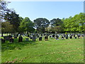
3
Need a Wii
Disused public convenience to the boundary of Eastham cemetery, alongside New Chester Road (A41).
Image: © J Scott
Taken: 10 Nov 2010
0.08 miles
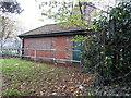
4
First Aid
St John Ambulance HQ, Bromborough.
Image: © J Scott
Taken: 29 Dec 2010
0.09 miles
5

Keep Left
Retail outlets along the A41, Eastham.
Image: © J Scott
Taken: 29 Dec 2010
0.10 miles
6
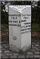
Old Boundary Marker by the A41, New Chester Road, Bebington Parish
Municipal Boundary Marker by the A41, in parish of Bebington (Wirral District), New Chester Road, on grass verge beyond pavement, corner of stone wall.
Inscription reads:- : BROMBOROUGH U. D. C. : : CHESHIRE COUNTY COUNCIL :
Surveyed
Milestone Society National ID: CH_BRCH01pb
Image: © Milestone Society
Taken: Unknown
0.11 miles
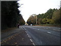
7
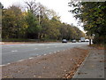
Going South
New Chester Road (A41), heading south towards junction 5 of the M53.
Image: © J Scott
Taken: 10 Nov 2010
0.14 miles
8
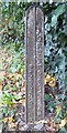
Old Milepost by the A41, north of Eastham
Cast iron post by the A41, New Chester Road, in parish of Bebington (Wirral District), North of Eastham, by cemetery, on the verge, on West side of road. Cast iron CCC1896, erected by the County Council in the 19th century.
Inscription reads:-
: BROMBOROUGH / 1 MILE / NEW FERRY 3 / BIRKENHEAD 5½ : : CHESHIRE / 1896 / COUNTY COUNCIL : : EASTHAM / ½ MILE / CHILDER / THORNTON 2 / LITTLE SUTTON 3 / GREAT SUTTON 3½ / CHESTER 10 :
Maker:-
: W H SMITH & CO / MAKERS / WHITCHURCH :
Merseyside HER.
https://www.heritagegateway.org.uk/Gateway/Results_Single.aspx?uid=3309320&resourceID=1970
Milestone Society National ID: CH_CHBH10
Image: © J Higgins
Taken: 1 Jul 2004
0.14 miles
9
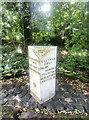
Old Milepost by the A41, north of Eastham
Cast iron post by the A41, New Chester Road, in parish of Bebington (Wirral District), North of Eastham, by cemetery, on the verge, on West side of road. Cast iron CCC1896, erected by the County Council in the 19th century. An earlier photograph can be found here https://www.geograph.org.uk/photo/5622707.
Inscription reads:-
: BROMBOROUGH / 1 MILE / NEW FERRY 3 / BIRKENHEAD 5½ : : CHESHIRE / 1896 / COUNTY COUNCIL : : EASTHAM / ½ MILE / CHILDER / THORNTON 2 / LITTLE SUTTON 3 / GREAT SUTTON 3½ / CHESTER 10 :
Maker:-
: W H SMITH & CO / MAKERS / WHITCHURCH :
Merseyside HER. https://www.heritagegateway.org.uk/Gateway/Results_Single.aspx?uid=3309320&resourceID=1970
Milestone Society National ID: CH_CHBH10
Image: © Nigel Upton
Taken: 1 Aug 2023
0.14 miles
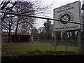
10
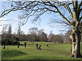
Eastham Lodge Golf Club
The 15th hole at Eastham Lodge Golf Club adjacent to Eastham Woods. The parkland course is just less than 6,000 yards in length and has plenty of mature trees, dog legs and some lengthy par threes.
Image: © Sue Adair
Taken: 1 Feb 2011
0.15 miles