IMAGES TAKEN NEAR TO
Mendell Close, WIRRAL, CH62 7JL
Introduction
This page details the photographs taken nearby to Mendell Close, CH62 7JL by members of the Geograph project.
The Geograph project started in 2005 with the aim of publishing, organising and preserving representative images for every square kilometre of Great Britain, Ireland and the Isle of Man.

There are currently over 7.5m images from over14,400 individuals and you can help contribute to the project by visiting https://www.geograph.org.uk
Image Map
Images are licensed for reuse under creativecommons.org/licenses/by-sa/2.0
Notes
- Clicking on the map will re-center to the selected point.
- The higher the marker number, the further away the image location is from the centre of the postcode.
Image Listing (7 Images Found)
Images are licensed for reuse under creativecommons.org/licenses/by-sa/2.0
Image
Details
Distance
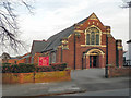
2
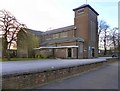
Church Of Christ The King, Bromborough
The Church of Christ the King on New Chester Road, Bromborough.
Image: © David Dixon
Taken: 3 Mar 2011
0.16 miles
3
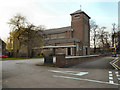
Church Of Christ The King, Bromborough
The Church of Christ the King on New Chester Road, Bromborough.
Image: © David Dixon
Taken: 3 Mar 2011
0.16 miles
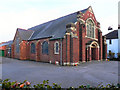
5
Bromborough Methodist Church
Bromborough Methodist Church, on Alport Lane.
Image: © David Dixon
Taken: 3 Mar 2011
0.24 miles
6
Bromborough Methodist Church
Bromborough Methodist Church, on Alport Lane.
Image: © David Dixon
Taken: 3 Mar 2011
0.24 miles
