IMAGES TAKEN NEAR TO
Laurelhurst Avenue, WIRRAL, CH61 9NY
Introduction
This page details the photographs taken nearby to Laurelhurst Avenue, CH61 9NY by members of the Geograph project.
The Geograph project started in 2005 with the aim of publishing, organising and preserving representative images for every square kilometre of Great Britain, Ireland and the Isle of Man.

There are currently over 7.5m images from over14,400 individuals and you can help contribute to the project by visiting https://www.geograph.org.uk
Image Map
Images are licensed for reuse under creativecommons.org/licenses/by-sa/2.0
Notes
- Clicking on the map will re-center to the selected point.
- The higher the marker number, the further away the image location is from the centre of the postcode.
Image Listing (7 Images Found)
Images are licensed for reuse under creativecommons.org/licenses/by-sa/2.0
Image
Details
Distance
1
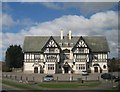
The Pensby Public House
The Pensby public house in Pensby Road.
Image: © Sue Adair
Taken: 9 Mar 2007
0.05 miles
3
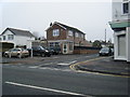
Post Office and shops on Pensby Road (B5138), Heswall
Image: © JThomas
Taken: 14 Sep 2019
0.12 miles