IMAGES TAKEN NEAR TO
Copeland Close, WIRRAL, CH61 8TH
Introduction
This page details the photographs taken nearby to Copeland Close, CH61 8TH by members of the Geograph project.
The Geograph project started in 2005 with the aim of publishing, organising and preserving representative images for every square kilometre of Great Britain, Ireland and the Isle of Man.

There are currently over 7.5m images from over14,400 individuals and you can help contribute to the project by visiting https://www.geograph.org.uk
Image Map (Loading...)


Getting Data...Please wait
Leaflet Map data © OpenStreetMap
Images are licensed for reuse under creativecommons.org/licenses/by-sa/2.0
Notes
- Clicking on the map will re-center to the selected point.
- The higher the marker number, the further away the image location is from the centre of the postcode.
Image Listing (6 Images Found)
Images are licensed for reuse under creativecommons.org/licenses/by-sa/2.0
Image
Details
Distance
2
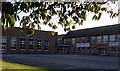
Pensby Girls High School
Happy girls achieve!
Image: © J Scott
Taken: 10 Oct 2010
0.08 miles
3
Sixth Form Block
Pensby High School for Girls, Irby Road, Pensby.
Image: © J Scott
Taken: 10 Oct 2010
0.11 miles
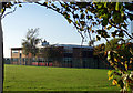
5
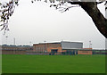
Pensby High School Sports Centre
Irby Road, Pensby
Image: © J Scott
Taken: 10 Oct 2010
0.16 miles
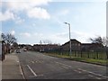
6
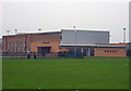
Pensby Boys' School Sports Centre
Irby Road, Pensby
Image: © J Scott
Taken: 10 Oct 2010
0.16 miles