IMAGES TAKEN NEAR TO
Thingwall Grange, WIRRAL, CH61 7YD
Introduction
This page details the photographs taken nearby to Thingwall Grange, CH61 7YD by members of the Geograph project.
The Geograph project started in 2005 with the aim of publishing, organising and preserving representative images for every square kilometre of Great Britain, Ireland and the Isle of Man.

There are currently over 7.5m images from over14,400 individuals and you can help contribute to the project by visiting https://www.geograph.org.uk
Image Map (Loading...)


Getting Data...Please wait
Leaflet Map data © OpenStreetMap
Images are licensed for reuse under creativecommons.org/licenses/by-sa/2.0
Notes
- Clicking on the map will re-center to the selected point.
- The higher the marker number, the further away the image location is from the centre of the postcode.
Image Listing (15 Images Found)
Images are licensed for reuse under creativecommons.org/licenses/by-sa/2.0
Image
Details
Distance
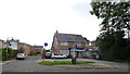
1
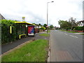
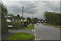
Bus stop and shelter on Barnston Road, Thingwall
The A551.
Image: © JThomas
Taken: 15 Jun 2019
0.04 miles
4
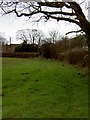
Footpath near Landican Road
A short footpath that leads from the busy A551/B5138 roundabout to Landican Hamlet.
Image: © David Quinn
Taken: 8 Mar 2008
0.17 miles
5
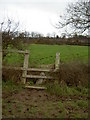
Stile on Footpath
A slightly wonky stile on the footpath to Thingwall, looking towards Thingwall. The footpath is well trodden and includes some extremely muddy sections.
Image: © David Quinn
Taken: 8 Mar 2008
0.17 miles

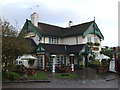
7
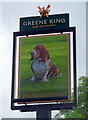
Sign for the Basset Hound, Thingwall
See Image] for context.
Image: © JThomas
Taken: 15 Jun 2019
0.21 miles